Archives

139 to 215 Lefferts Avenue / 158 to 214 Lefferts Avenue

Between Bedford and Rogers Avenues
Frank S. Lowe
1905

This block and many of its neighbors—those on Sterling Street, Lefferts Avenue and the north side of Lincoln Road between Bedford and Nostrand Avenues—are within the locally-designated Prospect Lefferts Gardens Historic District, but excluded from the National Register listing since historically they were not subject to the restrictive covenants that characterize Lefferts Manor to the south. This meant that developers were able to erect multiple-family dwellings including these 58 two-family rowhouses erected by the Kingston Realty Company. Architect Lowe designed these buildings to resemble their single-family counterparts, with only one entrance and stoop serving both apartments. The two-family model became especially popular in Brooklyn beginning in the 1890s as an affordable option for families, which could rent out the top floor while occupying the parlor and basement floors, and with developers, who were exempt from tenement house regulations (which only applied to dwellings with three or more families).

Cultural Landmarks, Citywide

New York City is known for many things: Art Deco skyscrapers, picturesque parks, the world’s greatest theater district, venerable museums and educational institutions, not to mention bagels and pizza! But above all of these, New York is most important as home to some of the world’s most fascinating and significant people and as the site of impactful and significant happenings throughout history. The city’s cultural influence is, perhaps, its greatest contribution to the world, and its built environment stands as a grand scavenger hunt of clues waiting to be uncovered. Lucky for us, the city’s Landmarks Law, passed in 1965, provides the legal framework for protecting the physical reminders of the city’s cultural wealth. In fact, one of the stated purposes of the Landmarks Law is to “safeguard the city’s historic, aesthetic and cultural heritage.”

In the first 50 years that landmarks were designated by the City, much emphasis was placed on the historic and aesthetic. In recent years, though, more consideration has been made for the importance of sites associated with people or historical events, rather than just for their architectural or historical value. In 2015, the NYC Landmarks Preservation Commission (LPC) designated the Stonewall Inn as an Individual Landmark solely for its association with the Stonewall Uprising of 1969. In 2018, the Commission designated the Central Harlem—West 130th-132nd Streets Historic District, describing it as “not only representative of Central Harlem’s residential architecture, but the rich social, cultural, and political life of its African American population in the 20th century.” Also, in recent years, Greenwich Village’s Caffe Cino and Julius’ Bar were listed on the National Register of Historic Places as significant and influential sites connected to the Lesbian Gay Bisexual Transgender (LGBTQ) community, The New York Times profiled a historian giving tours of Muslim sites of significance in Harlem, and the City is commemorating some of our most storied and accomplished female citizens with the installation of statues in all five boroughs. Indeed, grassroots preservation activism around the city is also swelling around sites of cultural significance: Tin Pan Alley and Little Syria in Manhattan, Walt Whitman’s house in Brooklyn, Arthur Avenue in The Bronx and a recently-rediscovered African burial ground in Queens, to name a few.

In response to this movement of interest in cultural landmarks, the Historic Districts Council undertook an initiative to highlight such places as one of its Six to Celebrate in 2018. The culmination of that effort was a conference in October 2018 entitled “Beyond Bricks and Mortar: Rethinking Sites of Cultural History.” The conference convened preservationists, historians, artists, planners, place-makers and more to work together to clarify what cultural significance is and how it can work, how to document and create compelling narratives around cultural sites, and how to identify the specific challenges of cultural sites from a preservationist perspective.

This brochure provides just a sample of some of the city’s cultural landmarks, organized thematically and representing all five boroughs. The list includes some sites that are legally protected — in some cases by more than one government body — and some that are unfortunately in danger of being lost. Preserving culturally significant sites that may not possess overtly aesthetic value often requires a particularly active and engaged form of advocacy to achieve protection from the wrecking ball. But, as long as there are interesting people making their mark on New York City and crucial events taking place here, that effort will never be in vain, since those stories are the lifeblood of this vibrant place.

Prospect Heights Apartment House District, Brooklyn

The Prospect Heights neighborhood is located immediately north of Prospect Park, bounded by Atlantic Avenue to the north, Eastern Parkway to the south, Flatbush Av- enue to the west, and Washington Avenue to the east. The area was home to the Le-nape Indians at the time of European contact. During the 18th century, the land came into possession of a number of different owners, several of whom were slave owners. It was still predominately farm and wood lands until the middle of the nineteenth century. The two most important factors in the growth of Prospect Heights were transportation improvements –which included new links between Prospect Heights and the ferries along Brooklyn’s waterfront- and the development of Prospect Park.

The original design of Prospect Park, like the original design of Central Park, was the work of the civil engineer Egbert Ludovicus Viele. In his 1861 plan, the park extended as far south as 9th Street, and as far north as Prospect Place. It included all the land between the present Prospect Park West and Washington Avenue, bisected by Flatbush Avenue. The city acquired all the land to execute Viele’s plan, but the Civil War put the execution on hold.

In 1865, consultant Calvert Vaux proposed that additional land be purchased to the south (to 15th Street) and east (to Ocean Avenue), and that everything east of Flatbush Avenue be jettisoned. The City of Brooklyn agreed, and figured they would just sell off the extra land. Construction began on Prospect Park in 1866 and the park opened to the public in 1871, although it was not yet complete. During the 1880’s, the city sold off the land between Sterling Place and Prospect Place, which was developed with row houses that are now the Prospect Heights Historic District. In 1898, when the City of Brooklyn became the Borough of Brooklyn, Park Slope was largely urbanized. P.S. 9 and its Annex (both designated NYC Landmarks) stood at Sterling Place and Vanderbilt Avenue, the Brooklyn Museum had recently opened (only about a quarter as large as it is today), the Soldiers’ and Sailors’ Memorial Arch was in place, and Frederick MacMonnies’s bronze quadriga had just been placed atop it.

Prospect Heights north of Sterling Place (Butler Street) was an established area, but not the “East Side Park Lands.” The land between Eastern Parkway and St. John’s Place was mired in litigation over title to the land, and remained undeveloped until well after the turn of the century. There were buildings along Plaza Street to the west of the oval plaza, but no buildings on Plaza Street to the east. By 1908, the Museum had more than doubled in size, but the East Side Park Lands remained empty. Meanwhile, Bedford-Stuyvesant was intensively developed.

This development delay led into the apartment house era. The 1920 opening of the IRT Subway extension under Eastern Parkway spurred the construction of six-story elevator apartment houses. This typology was an attractive choice for developers, as the NYC Building Code only required the first two floors of six-story buildings to be fireproof, as opposed to all floors of seven-story buildings. In 1915-16, the Martinique building, at 163- 169 Eastern Parkway, was the first building to rise on the land. Many followed, making the East Side a rare example, especially in Brooklyn, of a central area developed with apartment houses from the start.

Engine Company 236

998 Liberty Avenue
1895

“BFD,” the initials fancifully engraved just above the first story of this Romanesque Revival style fire station, say a lot more than one might think on first glance. Standing for “Brooklyn Fire Department,” the initials confirm that this building dates to sometime between 1869, when the Brooklyn Fire Department was organized, and 1898, when the boroughs were consolidated to form the Greater City of New York. The Brooklyn Fire Department only lasted a few decades before merging with the FDNY after the city’s consolidation. Interestingly, this building was constructed in 1895 to house Engine 36, so it only served the Brooklyn Fire Department for about three years. Shortly after the consolidation, the fire companies were renumbered to avoid confusion, and this company became Engine 136 until 1913, when it was reorganized again to become Engine 236. Referred to as “The Pride of East New York,” Engine 236 continues to serve the community today.

Glenmore Avenue Presbyterian Church

994 Glenmore Avenue
1899

This lovely Shingle Style church at the corner of Glenmore Avenue and Doscher Street might seem more at home on a country lane in the Hudson Valley, but when it was constructed in 1899, East New York was still a quiet suburban enclave. It was built for the Glenmore Avenue Presbyterian Church, which is still an active congregation. While the structure has suffered some insensitive alterations, including the loss of its original clapboard siding and the replacement of its front porch, it retains its general massing, including a graceful and oversized corner tower with an arched belfry and bell-shaped roof, as well as most of its original windows and dormer windows on both of its side facades.

Former Brooklyn Post Office

950 Glenmore Avenue
c. 1920

This charming building originally served as the New Lots Post Office, as evidenced by the faded letters just below the cornice that read “BROOKLYN POST OFFICE.” At the time the building was constructed in the 1920s, it cost just twenty cents to send a package via first class mail. Though most of the building’s window openings have been filled in, its symmetrical façade still features many original details, like arched windows, Corinthian style pilasters and a bracketed cornice. Due to the construction of a new post office on Sutter Avenue, the building was sold in the 1960s to Milford Tile, which continues to operate it as their Brooklyn-based showroom.

Public School 149 The Danny Kaye School

700 Sutter Avenue
Charles B. J. Snyder
1906

Public School 149 was one of the roughly 400 schools constructed during the tenure of the notable architect/engineer C. B. J. Snyder, superintendent of school buildings for the Board of Education from 1891 to 1923, when the city’s population was growing and new laws mandated children’s education. Snyder was known for his innovative “H-plan” design, inspired by the medieval Hôtel de Cluny in Paris, which allowed for improved ventilation, advances in fireproofing, better lighting, larger classroom sizes and the incorporation of two courtyards for recreation. Public School 149 initially housed kindergarten through ninth grade classes, but in the 1920s was downsized to offer only sixth, seventh and eighth grade classes when the city adopted a Junior High School system in an effort to relieve overcrowding. At that time, it became known as either Junior High School 149 or East New York Junior High School. In 1967, the city opened another junior high school nearby, I.S. 292, and P.S. 149 became an elementary school. The school is named for famed actor, dancer and musician Danny Kaye (born David Daniel Kaminsky), one of the school’s most illustrious alumni (he attended from 1919 to 1927), who also attended Thomas Jefferson High School.

Thomas Jefferson High School

400 Pennsylvania Avenue
Probably Charles B. J. Snyder, New York City Board of Education
1922-24

In 1921, plans to build a high school in East New York were made public. Prior to that, students had to travel significant distances to schools outside of the neighborhood, so the announcement was extremely well received. In May 1922, Mayor John Francis Hylan, local leaders and six live bands led the parade and celebrations surrounding the school’s groundbreaking ceremony. Dedicated to the third President of the United States, Thomas Jefferson High School opened with roughly 4,000 school seats in September 1924. Some of the school’s notable attendees include Howard Zinn, Danny Kaye, Shelley Winters, Jimmy Smits and Al Lewis, who played Grandpa Munster in the 1960s TV show The Munsters.

St. Michael’s Roman Catholic Church

225 Jerome Street
Church: 1920-22
Supporting buildings: 1897-1956

St. Michael’s Roman Catholic Church has served its community for over 150 years, during which time its campus grew to occupy almost the entire block between Atlantic and Liberty Avenues and Jerome and Warwick Streets. In 1860, a group of German immigrants received authorization from John Loughlin, the first Bishop of the Diocese of Brooklyn, for the construction of a Roman Catholic Church in New Lots. A wood frame structure was erected that same year, with Bishop Loughlin himself dedicating the site. Soon after, a school and rectory building was constructed next door. In 1897, a larger brick elementary school was constructed at the corner of Warwick Street and Liberty Avenue. The campus continued to expand with the enlargement of the rectory and the construction of more educational facilities on Warwick Street. By 1920, the growing parish was in need of a larger worship space, so a grand Romanesque Revival style church with an elegant bell tower was planned to take the old church’s place. The new church extended the width of the block to Warwick Avenue, where it also extended northward to accommodate a new monastery. In 1956, a high school was built at Jerome Street and Liberty Avenue. While the church originally served a German congregation, its demographics shifted over the years to serve Irish, Polish and Italians, and later African Americans, Puerto Ricans, Dominicans and Mexicans. Today, its congregation is predominately Spanish-speaking. In 2006, the church merged with St. Malachy Roman Catholic Church, a historically Irish parish in East New York, to form the new parish of St. Michael-St. Malachy.

Vienna Flats

2883 Atlantic Avenue
William Danmar
1885-90

This Queen Anne style apartment building was commissioned one year before East New York was annexed as part of the City of Brooklyn. Upon its completion in 1890, it was the largest building in the area, designed to cater to small, working class families, with rental apartments advertised in the Brooklyn Eagle for $10.00 per month and up. Its Danish architect, William Danmar, was also an author, notable professor of architecture at Cooper Union and one of the founding members of the Architecture Department of the Brooklyn Institute of Arts and Sciences (precursor to the Brooklyn Museum). Although many of its architectural details have been lost over the years, the Vienna Flats retains its mansard roof with pedimented dormer windows and its distinctive curved corner bay, which runs the entire length of the building. The curved bay has a swooping entrance hood at the bottom and bears the building’s name in large capital letters at the top.

Empire State Dairy Company (later Borden Dairy Corporation) Buildings

2840 Atlantic Avenue
Theobold Engelhardt and Otto Strack
1906-07 and 1914-15
NYC Individual Landmark

Constructed as a dairy distribution center for the Empire State Dairy Company, this complex was sold soon after completion to the Borden Dairy Corporation. The complex was built in two stages, with the earlier buildings at Atlantic and Schenck Avenues completed in 1907 and the later ones just east on Atlantic Avenue completed in 1915. Unlike most factories, where functionality takes precedence over design, the buildings exhibit fine architectural details, including two remarkable terra cotta murals facing Atlantic Avenue. One depicts a woman leading a cow and a calf to water and the other depicts a man leading a bull to water. The characters in these scenes are set within bucolic, lush landscapes of water, meadows, pines and mountains, harkening to the agrarian beginnings of the dairy industry. The murals were manufactured by the American Encaustic Tiling Company, and are considered the largest extant decorative tile installations by the company. In large part due to the rarity of these art works, members of the local community were instrumental in advocating for the designation of the complex as a New York City Individual Landmark, which was finalized in 2017.

New Lots Town Hall

109-111 Bradford Street
Architect unknown
1873

This structure stands as a rare remnant of the town of New Lots. In 1873, the newly established and growing town authorized a $10,000 bond for the construction of a town hall. Opening in December of that year, this building included office space, rooms for public assembly and a fire department. Later, space was made for a police force and jail cells, as well. After New Lots became the 26th Ward of the City of Brooklyn in 1886, a town hall was no longer necessary and the building became the 71st police precinct until 1892, when a larger police station was built at 484 Liberty Avenue. In 1899, the building became the 26th Ward Homeopathic Hospital and Dispensary, later the Bradford Hospital, until it closed in 1934. Eventually, the building was converted into a multi-family residence. Today, while its large windows have unfortunately been shrunk, their lintels and sills remain as a memory of the original openings. The building also retains its cornice and 1930s entrance porch.

Mrs. Maxwell’s Bakery

2700 Atlantic Avenue

A crucial stop on a tour of the neighborhood is Mrs. Maxwell’s Bakery, which has been serving the community since 1928. During World War II, the bakery, previously known as “Essential Cheesecake,” changed its name in a bid to secure a contract to provide baked goods to the troops stationed at Fort Hamilton. “Mrs. Maxwell” was conceived as a motherly, nurturing mascot by the bakery’s owners, who sought to tug on the heart-strings of the procurement decision makers. Their effort paid off, and Mrs. Maxwell’s Bakery was awarded the contract. The fictional Mrs. Maxwell has been an integral part of the business ever since, and the bakery continues to serve a loyal clientele. Try one of her pastries or take home one of her cakes. You will undoubtedly return!

Prince Hall Masonic Lodge

68 Pennsylvania Avenue
Harde & Short
1906-07

With much fanfare, a procession marched on July 29, 1906, from Liberty Avenue to 68 Pennsylvania Avenue, where the cornerstone was laid to begin construction of the Tyrian Masonic Lodge. The Tyrian Masons trace their history back to the ancient Biblical city of Tyre, but this particular lodge, number 618, was founded in 1867. The organization had previously been headquartered in a building on Atlantic Avenue and then in Happ’s Hall at Liberty and Wyona Avenues before constructing this larger building. Pennsylvania Avenue runs through East New York and the adjoining neighborhood of Cypress Hills, and was once a premier avenue, making it a desirable location for the new headquarters. The organization’s membership consisted of upper middle class men, but the building was also home to the Tyrian Ladies Auxiliary, a charitable group. In 1971, the property was acquired by the Prince Hall Masons, an African-American Masonic body, so named in honor of an African-American abolitionist recognized for his leadership in the free black community. Although a community center primarily operates here today, it has been reported that the free masons still utilize the space.

Piels Brewery

124-128 Sheffield Avenue
c. 1900

Considering East New York’s thriving German immigrant population in the second half of the 19th century, it is no surprise that the neighborhood was once home to a significant brewing complex, the Piels Brewery. In 1883, Gottfried, Wilhelm and Michael Piel – three brothers from Düsseldorf, Germany – purchased a small brewery at Georgia and Liberty Avenues and slowly expanded the complex. Its success was largely due to the ingenuity and skill of the youngest brother, Michael, who incorporated traditional brewing techniques with the new science of refrigeration. As expected with any large brewery at that time, the location included a traditional, open-air beer garden for its patrons. In 1912, due to the brand’s growing popularity, the brothers closed the garden in order to expand the brewery itself. After surviving Prohibition by producing “near beer,” the brand installed the world’s largest beer sign, featuring neon lights, atop the complex in 1936. The Piels brewing legacy lasted for ninety years until September 1973, when it closed its doors. At that time, much of the complex was demolished, though this structure still stands as a reminder of the once thriving local business and East New York’s German heritage. Also surviving at 315 Liberty Avenue is the company’s 1959 Administration Building, whose original Modern style has unfortunately been altered beyond recognition.

Cornerstone Seventh-Day Adventist Church

138 Pennsylvania Avenue
Builder: Frank Richards
1922

This stately structure was built in 1922 as the Homestead Branch of the National City Bank of New York, an institution founded in 1812 and known since 1976 as Citibank. A Brooklyn Eagle article from January 9, 1922, described it as “a handsome, but not extravagant, structure, with all the up-to-date appointments of a first-class bank.” The same article described some of its interior features: “There are windows on three sides, admitting real daylight into the tellers’ and bookkeepers’ cages. The finish of the cages is Tennessee marble and bronze. Metal desks that have the verisimilitude of mahogany harmonize with real mahogany trim and chairs.” In 1977, the property was sold to the Cornerstone Seventh-Day Adventist Church, which made only minimal changes to the front façade, including the addition of a sign and awning over the entrance and the removal of its original sign band above the grand columns, which read “The National City Bank of New York.” Its conversion to and continued function as a church is an excellent example of successful adaptive reuse.

Former Magistrate’s Court

135 Pennsylvania Avenue
Mortimer Dickerson Metcalf
1929

While many buildings on Pennsylvania Avenue have been altered or demolished, it was once considered East New York’s grand boulevard, home to fine residences and institutional buildings, including this former courthouse. Designed in the neo-Classical style popular for government buildings at the time, the Magistrate’s Court was the work of Mortimer Dickerson Metcalf, who previously worked for the prestigious New York architectural firm of Warren & Wetmore (architects of Grand Central Terminal). It was one of many such courthouses in Brooklyn, where low-level criminal cases were heard until the city’s court system was centralized in 1962 (the building’s near-twin, an individual landmark also designed by Metcalf, is located at 4201 4th Avenue in Sunset Park). The location, previously home to St. Clement’s Protestant Episcopal Church, was likely chosen for its proximity to the local police precinct (site 4). After 1962, the building housed the Arnold and Marie Schwartz Community Center, a day care program, the Police Athletic League and the offices of Brooklyn Community Board 5. In 2009, due to a lack of funding, the community center was forced to close, but new funds set aside in the 2015 East New York Neighborhood Plan should enable its reopening. Despite its change of use, the building’s history as a courthouse remains legible through an inscription on the frieze that reads “MAGISTRATES COURT.”

Former 75th Police Precinct Station House

484 Liberty Avenue
Emile M. Gruwe
c. 1886-92
National Register of Historic Places

To protect its rapidly growing population in the 1880s and 1890s, Brooklyn greatly expanded its police force and built precincts throughout its neighborhoods. This magnificently adorned but dilapidated structure served as the 75th Precinct until the 1970s. Affectionately known to the local community as “The Castle,” it was designed in the Romanesque Revival style with Venetian and Norman Revival ornament, including brick molded cornices, arched openings, brownstone moldings and stone bandcourses with carved faces and Byzantine leafwork. It originally had a crenellated roofline, lending it a fortress-like quality, but that detail has been removed. In 1976, the People’s First Baptist Church bought “The Castle” at auction from the City, but due to the declining health of the church’s owner and faith leader, the building fell into disrepair. In 2016, the building again changed hands, but its future is uncertain. A near-identical twin of this building, designed by the same architect, stands at 4302 Fourth Avenue in Sunset Park, Brooklyn and was designated as an individual landmark in 1983. That building is also in a state of disrepair but is currently being considered for use as a public school.

Grace Baptist Church of Christ

233 New Jersey Avenue
Architect unknown
1898

This stately Gothic Revival style church was originally built for the German congregation of St. John’s Evangelical Lutheran Church, which referred to itself as St. Johannes Evangelisch-Lutherische Kirche – a name memorialized in stone at the base of the church’s tower. From its formation in 1847, this German immigrant congregation worshipped in a wooden church building at the corner of New Jersey and Liberty Avenues, making it one of East New York’s earliest institutions. The new church, constructed just south of the original building, was dedicated in 1898. Committed to staying connected to their heritage, the members of the church spoke German and for many years refused to conduct services in English. This was largely in response to the early 20th century trend of German congregations switching to English-speaking services. This eventually led to a schism in the congregation, wherein a group broke off to form the English-speaking Lutheran Church of the Reformation on Barbey Street. By the mid-20th century, most of the German population had moved out of East New York, so in 1972, the parish voted to disband and sold the building to the congregation of Grace Baptist Church of Christ, which continues to worship here. The structure is adjoined by a charming rectory building, faced in the same rough-hewn brick as the church.

Second Calvary Baptist Church

503 Glenmore Avenue
Architect unknown
1921

There is a longstanding tradition in New York City of adapting religious buildings for use by other religious groups, and the Second Calvary Baptist Church is a shining example of this practice. This structure was originally constructed for the Agudath Achim B’nai Jacob Synagogue, which operated here until transferring ownership in 1974 to the Second Calvary Baptist Church. Remarkably, while the church made changes to adapt the building, it left nearly all of the Jewish iconography and ornament intact on the building’s exterior. If not for the church’s new signs at the corner of Glenmore and Miller Avenues, the grand structure would appear to still function as a synagogue, as it retains Hebrew inscriptions above the three entrance doors, a prominent depiction of the Torah in the center of the building’s pediment, three large sculptures of the Star of David on the roofline and stained glassed windows containing the Star of David. Through the preservation of these elements, the new congregation has honored the building’s past, beautifully merging the old and the new. Aside from its religious symbols, the building commands a strong presence with its Classical style temple front, sculptural details, decorative brickwork and iron fence, which are all wonderfully intact.

Holy Trinity Russian Orthodox Church

400 Glenmore Avenue
Roman Meltzer
1935

Founded in 1909 by immigrants from Belarus, the Holy Trinity Russian Orthodox Church commissioned this magnificent structure a few decades later, with construction completed in 1935. The church was designed in the traditional Russian Orthodox style by Roman Meltzer, a notable Russian-born architect. Before arriving in New York in 1921, Meltzer worked as an architect and decorator for several of the Imperial palaces in St. Petersburg, and was appointed court architect in 1903. He was best known for his Art Nouveau style interiors and for the wrought-iron grillework he designed for the Winter Palace entrance gates and garden railing. In the late 1950s, the interior of the Holy Trinity Russian Orthodox Church was redecorated with murals by the famed iconographer Pimen M. Sofronoff.  On the exterior, the church’s domed copper roofs, which have tarnished to reveal a beautiful green patina, have become neighborhood icons and serve as a beacon to those of the Russian Orthodox faith. After many years of coping with a diminishing congregation, the church’s membership has increased in recent years due to an influx of Russian immigrants to southern Brooklyn.

1362 President Street

Cohn Brothers
1921
(“Millionaire’s/Doctor’s Row”)

This over-the-top mansion was built for real estate developer Louis Halperin. Its architects, the Cohn Brothers, designed hundreds of apartment buildings and a few private homes in New York City for people like themselves – the children and grandchildren of Jewish immigrants. This brick and limestone house, mostly designed to impress, is not confined to one style, but rather contains a mixture of elements from the French Renaissance, Romanesque Revival and Georgian styles. One of its more pronounced – and unusual – features is its grand porte-cochere, which today harkens back to the glory of the automobile’s early days, a common theme found in the architecture of Crown Heights South.

1337 President Street

William Van Alen
1914
(“Millionaire’s/Doctor’s Row”)

Though this Beaux-Arts style structure has the appearance of one large mansion, it is, in fact, a pair of houses unified by its symmetry and Classical details. Willliam Debus was a prolific late 19th and early 20th century architect in Brooklyn who specialized in Parisian-style flats and tenement buildings, as well as elegant Beaux-Arts style townhouses, such as these. The house features a grand portico entrance, elaborate window surrounds, a deep cornice and garages in the rear. While all of the structures on the block are set back from the street by elegant lawns, a wide porch with a stone railing lends the building a commanding presence, even on this block of very impressive architecture.

1290-1294 President Street

William Debus
1911
(“Millionaire’s/Doctor’s Row”)

Though this Beaux-Arts style structure has the appearance of one large mansion, it is, in fact, a pair of houses unified by its symmetry and Classical details. Willliam Debus was a prolific late 19th and early 20th century architect in Brooklyn who specialized in Parisian-style flats and tenement buildings, as well as elegant Beaux-Arts style townhouses, such as these. The house features a grand portico entrance, elaborate window surrounds, a deep cornice and garages in the rear. While all of the structures on the block are set back from the street by elegant lawns, a wide porch with a stone railing lends the building a commanding presence, even on this block of very impressive architecture.


“Millionaire’s/Doctor’s Row Houses”

President Street between New York and Kingston Avenues

These two blocks represent some of Brooklyn’s finest early 20th century mansion architecture. While much of Crown Heights South was experiencing dense development to accommodate a growing middle-class population, this stretch of property was being developed to appeal to wealthy industrialists and professionals, and the result is a neighborhood that one might more easily expect to find in a wealthy suburb on Long Island. Unlike the late 19th century mansions of Victorian Flatbush, also in central Brooklyn, these early 20th century gems were built during a time of even greater prosperity just before the Great Depression hit. However, it is possible that the configuration of the mansions set back from the street by lush front lawns was borrowed from that very successful development in Flatbush. Both neighborhoods benefit from a strong overall character and sense of place, provided by the unified scale of the buildings and the existence of beautiful green space that is visible from the public way. The architects here ranged from a young William Van Alen, who would later design the Chrysler Building, to the Cohn Brothers, William Debus and Henry M. Congdon. By the 1930s, these two blocks became home primarily to doctors, many of whom worked at nearby St. Giles, Kings County and other hospitals. It is still known today as both “Millionaire’s Row” and “Doctor’s Row” due to these historical associations.

341-347 New York Avenue and 1268-1270 President Street

Montrose W. Morris
1912

Designed by famed Brooklyn architect Montrose W. Morris, these two pairs of double duplex homes were among the architect’s last commissions in New York City. While very different from his earlier Romanesque Revival and Renaissance Revival style works in Bedford Stuyvesant and Park Slope, these Beaux-Arts/Colonial Revival style homes share the Morris signatures of large overhanging bracketed cornices and elegant detailing. Each unit, with its own entrance and street address, was designed as a two-family home, with two two-story apartments in each. The buildings are faced in red and tan brick with limestone trim, with side quoins, Juliette balconies and columned entry porches. The buildings have a back service alley. Some unfortunate alterations were made over the years, including the removal of the cornice on number 347 and the loss of all of the original doors. The buildings, unlike the mansions around the corner on President Street (site 18), were constructed to capitalize on the area’s influx of middle-class residents. This early 20th century shift to communal-style living is represented in Crown Heights South’s many two-family rowhouses and apartment buildings. These structures at the intersection of New York Avenue and President Street represent an interesting cross between the two.

St. Mark’s Day School

1346 President Street
Ludlow & Peabody
1916

Built as the Hospital of St. Giles the Cripple, this building was constructed at a time when polio and other crippling childhood diseases were at almost epidemic proportions. The hospital, whose original location was on DeGraw Street in Cobble Hill, was founded in 1891 by an Episcopalian nun and was one of the first hospitals dedicated to the orthopedic care and treatment of children. The hospital raised enough money to build a larger facility, and despite initial community opposition, relocated here in 1916. Designed by the prominent firm of Ludlow & Peabody, which specialized in institutional architecture, the Spanish Mission Revival style might have been chosen for its association with sunny and warm climates, in order to inspire its young patients with thoughts of ample light and fresh air. At the charity’s peak in the first half of the 20th century, annexes were also constructed in Long Island and Garden City, New Jersey. In the 1950s and early 1960s, the Salk and Sabine vaccines had finally conquered polio, and by the 1970s, orthopedic care was incorporated as a service offered in larger hospitals. Therefore, in 1978, St. Giles closed the hospital and sold the building to St. Mark’s Episcopal Church across the street. The church transformed the building into the St. Mark’s Day School, a parochial school for students from pre-Kindergarten to 8th grade, and the building still operates as such today.

1301-1337 Carroll Street

Slee & Bryson
1913

Brooklyn’s most prolific architectural firm specializing in the Colonial Revival style was that of Slee & Bryson, who, in addition to designing Colonial Revival style architecture in Crown Heights South, also built similar rowhouses in nearby Lefferts Manor, Albemarle and Kenmore Terraces, Park Slope and Crown Heights North. This row of houses included such popular Colonial style details as dormers, fan lights and white trim on red-brick, all of which could be seen on much of the American residential architecture of this style in the early 20th century. While many of the houses in this remarkably long row have been altered with unsympathetic details, such as patches of vinyl siding and window grilles, the row is still largely intact and stands out for its fine proportions and overall rhythm.

1237-1297 Carroll Street

John Wandell
1913

The mixture of Renaissance Revival and Colonial Revival style details in these alternating bow- and flat-front houses is unique to Crown Heights South. To visually link these different stylistic elements, which were not typically found side-by-side or on the same structure, architect John Wandell designed some of them to have a common cornice line and a molded belt course over the first floor. Unlike earlier rowhouses, many of the houses have English style stoops, which rise to only a few steps above street level, rather than the classic high stoops of the late 19th century.

“Spotless Town” Houses

1423-1454 and 1368-1410 Union Street
Henry M. Congdon & Son
1902-04

Designed by the same architectural firm as St. Mark’s Episcopal Church (site 12), this block was planned and executed as an upscale development of single-family homes. Congdon designed large, semi-detached homes in the Edwardian English and Flemish Revival styles, creating suburban elegance in an urban setting. The houses, touted for their beauty, were also cutting-edge for the shared amenities introduced by the developer, the Eastern Parkway Company. These included a power plant that pumped central heating to all of the houses and back service alleys for automobiles. The latter was an idea that quickly inspired other developments in Crown Heights South, and is now a distinctive feature of many blocks in the neighborhood, emphasizing the importance of the automobile at the time the neighborhood was being built up. Another amenity that this block enjoyed was gated entry for privacy purposes. This feature gave rise to the nickname “Spotless Town.”

St. Mark’s Episcopal Church

1417 Union Street
Henry M. Congdon & Son
1907; additions: 1937

This Romanesque Revival style building was designed as the community center for a large church planned for the lot next door that was never built. The building included a basement gym, kitchen, auditorium and classrooms. Interestingly, the firm had recently designed the homes on the opposite side of Union Street (site 13), thus allowing for a certain continuity and design harmony on the block. Thirty years after designing the original structure, the architectural firm of Henry M. Congdon & Son returned in 1937 to permanently transform the building into a church, adding Gothic details with a new sanctuary, steeple, entrance and stairway. The corner structure benefits from being set back by grassy lawns from both Union Street and Brooklyn Avenue, lending it a pleasant stature in addition to its architectural charm.

1361-1381 Union Street

Axel Hedman
1912

When rowhouse development began in Crown Heights South in the early 20th century, Renaissance Revival style architecture was still very popular. Typified by the use of limestone cladding and Classical ornamentation, rowhouses designed in this style are quite numerous across the neighborhood. Prolific architect Axel Hedman designed some of the best, and put his signature touch on this group, alternating façade designs and sculptural ornamentation. These homes are especially unique for their distinctive roof parapets and railings, as well as for the fact that they are exceptionally intact.

Troop C Armory (aka Bedford Armory)

1555 Bedford Avenue
Pilcher & Taschau
1903-1906

This massive structure was New York City’s first National Guard cavalry unit armory, and is the only Art Nouveau-inspired armory in Brooklyn. Architect Lewis F. Pilcher designed a unique stable wing within the building that could sanitarily house 117 horses – a major feat in the urban environment of Brooklyn. He utilized various levels and pitches for his floors, a complex drainage system and an abundance of windows and vents, all hidden behind the bays of the President Street exterior. The armory’s enormous drill shed, extra tall for ventilation, was also used for sporting and social events, and more recently, as a stage for movie sets. The administrative wing housed officer’s quarters and meeting rooms. The armory functioned as an active National Guard unit until as recently as 2011. Despite its important history and architectural contribution to the neighborhood and the city, the structure is unfortunately not protected as a designated landmark. Many local and citywide activists are concerned that the building could be in danger of becoming the centerpiece of an inappropriate and unsympathetic development project that would destroy the original façade of its signature stable wing, and loom over the surrounding neighborhood.


1590 Bedford Avenue

Architect unknown
1926

America’s love affair with the automobile was in full swing by 1924, when Guy O. Simons was appointed by Walter Chrysler to oversee all of the Chrysler dealerships in Brooklyn and Long Island. This building was constructed as a service center, storage facility and garage for the Simons Motor Sales Company. It served his Chrysler and Maxwell showroom, which was located farther north on Bedford Avenue. Simons’ building is a classic, early 20th century commercial warehouse structure, but is embellished with the Tudor styling so popular at the time, especially in suburban residential architecture. The clinker bricks and decorative roof parapet add charm and visual interest to what could have otherwise been a very plain utilitarian garage.

CUNY Medgar Evers College Building

1150 Carroll Street
Architect unknown
1908

Constructed on the foundations of the old Kings County Penitentiary in 1908, this large, Beaux-Arts style building was built as the Brooklyn Preparatory School by the Jesuits. The school complex then grew to include playing fields and supporting classrooms. The all-male institution provided a superior classical education to students who went on to careers in law, business and the arts. Graduates included William Peter Blatty, author of the Exorcist, and Joseph Califano, United States Secretary of Health, Education and Welfare under President Jimmy Carter. Brooklyn Prep’s final class graduated in 1972, after which the building was sold to the City University of New York (CUNY), which opened Medgar Evers College in the complex. The school has flourished and expanded to include a much larger campus along Bedford Avenue and the surrounding streets.

The Pasadena Apartments

132-152 Crown Street
Architect unknown
1928-1930

Typical of the era’s “Classic Six” apartment buildings, the Pasadena was designed to appeal to the emerging middle class moving to Brooklyn in large numbers, arriving via new subway lines. Its Spanish/Mediterranean Revival design is characteristic of the era’s penchant for Tudor, Medieval and Spanish Revival suburban homes, which was echoed in apartment house styles in the urban environment. These apartment buildings offered tenants such amenities as impressive marble lobbies, large apartments with multiple bedrooms, sunken living rooms and a maid’s room and bath off the kitchen. In addition, many of these buildings were given fancy names to evoke a certain stature and identity; in this case, the distant and beautiful city of Pasadena. It is possible that Pasadena’s allure was also derived from its proximity to Hollywood, which was, at the time, reaching its peak of glamour and influence across the United States. The building is accessed through a graceful open courtyard in the front, allowing residents and visitors a grand entrance and reinforcing the building’s persona to passersby.

Firestone Tire and Service Station

1728 Bedford Avenue
Architect unknown
circa 1928

During the first half of the 20th century, Bedford Avenue was known as “Automobile Row,” with car dealerships and service centers between Fulton Street and Empire Boulevard. This Art Deco/Streamline Moderne style service station, which still sells Firestone products, was patronized by auto buyers and sports fans from nearby Ebbets Field. Although the building has been modernized over the years, the original cantilevered roofline has not lost its Streamline Moderne curves. However, because of rapid development along Empire Boulevard, this building is also in danger of being lost.

73-97 Empire Boulevard

Architect unknown
circa 1914

In 1913, Ebbets Field, home of the Brooklyn Dodgers, was one of the most popular gathering places in all of Brooklyn. To accommodate traffic to the stadium and to capitalize on patronage by the team’s fans, Empire Boulevard and the surrounding streets became home to an array of parking garages. Despite the utilitarian function of these one-story buildings, their façades were still richly adorned with a rhythm of terra cotta Gothic arches along the roofline, perhaps reminding sports fans of their religion – baseball. This building, which was converted to retail and commercial space, is one of the last remaining garage structures in this area, and is unfortunately in danger of being lost to a redevelopment scheme due to its location on Empire Boulevard, now a bustling thoroughfare.

Morris J. Golombeck Spice Company

960 Franklin Avenue
Architect unknown
1900

A sure sign of approaching this industrial complex is the pleasant scent of cardamom and cinnamon wafting down the street. Before it became the Morris J. Golombeck Spice Company in 1955, it was originally constructed as the Consumer’s Brewery, the first brewery in the United States to be powered entirely by electricity. In addition to the brewery, in its heyday, this multi-building complex also housed the long-gone Brick Garden Hotel – a restaurant, beer garden and entertainment venue. Notably, the complex’s influence was such that it had its own stop on the Brighton Line of the subway, now part of the Franklin Avenue shuttle. The business later merged with the Interboro Brewing Company, but unfortunately failed with the advent of Prohibition. At that time, the subway station closed and the platform was removed. The handsome Romanesque Revival style factory and its Queen Anne style auxiliary building are endangered treasures in this area of low density and large lots. Development has already claimed the lots across the street, once home to a commercial laundry complex.

Philadelphian Sabbath Church

530 Eastern Parkway
Harrison Wiseman
1924

This Egyptian-inspired, Art Deco style theater opened in 1924 as the Cameo Theater. A year later, it was purchased by the Loews chain and renamed the Kameo. The exterior is striking for its multiple rows of polychrome terra cotta tile, highlighted by a frieze incorporating a stylized Muse repeated across and around the façade. The theater also features a roof garden auditorium and screening wall, which can be seen from the back and sides of the building. The 1500-seat theater was a neighborhood fixture until it closed in 1974, when the building was purchased by the Philadelphian Sabbath Church, an African-American Pentecostal congregation. Luckily, much of the original interior remains intact.

Calle 59 Entre la Cuarta y Quinta Avenidas (4th and 5th Avenues)

411-471 Henry Spicer, 1895;
412-440 Frank S. Lowe, 1896;
444-468 Henry Pohlmann, 1902|

Esta cuadra muestra la arquitectura de casas en hilera que define Sunset Park. En la parte norte hay 26 casas, inusuales por su fachada plana, las cuales fueron diseñadas por la misma persona. Atravesando la calle, hay 13 casas de dos arquitectos diferentes. Todas tienen miradores que sobresalen, lo cual crea un contraste muy interesante con la parte norte de pared plana.

Nuestra Señora del Perpetuo Socorro y Escuela San Alphonsus – EN ESPAÑOL

526 59th Street Franz Joseph Untersee, 1905-28;
5902 Sixth Avenue 1902-03|

La basílica de Nuestra Señora del Perpetuo Socorro es la edificación religiosa más grande en Long Island y ocupa la cuadra entera. La basílica neorrománica de granito es una iglesia doble con dos pisos para la oración. La planta baja fue construida en 1909 y el segundo piso en 1928.  En sus primeros años la parroquia consistía en su mayoría de congregantes irlandeses. En la actualidad, algunos irlandeses siguen asistiendo, pero la congregación es ahora en su mayoría hispana y china. Las construcciones complementarias incluyen la casa del párroco, la cual tiene un estilo neorrománico con ladrillo, con detalles neogóticos y molduras de terracota y está ubicada detrás de la basílica; también St. Alphonsus School en la Sexta Avenida, el cual antedata a la basílica por varios años. Esta escuela fue diseñada con estilo gótico ruskiniano y un extravagante enladrillado beige y negro, además tiene una puerta con forma de arco apuntado y con aberturas de ventanas y una estatua central por encima de la entrada.

El Barrio Chino – EN ESPAÑOL

Eighth Avenue entre 42nd y 68th Streets|

Este es el tercer barrio chino en la ciudad de Nueva York. Los inmigrantes chinos llegaron a Brooklyn desde el barrio chino de Manhattan en 1980, viajando en la línea N del tren desde Canal Street hasta 62nd Street. Debido a que la estación está por encima del suelo y al aire libre, los inmigrantes chinos la llamaron “Estación del Cielo Azul”, lo cual también hace referencia al ambiente suburbano de este barrio de Brooklyn.

El Cementerio Green-Wood – EN ESPAÑOL

Cementerio Green-Wood

El cementerio Green-Wood está situado al norte de Sunset Park. Abrió en 1838 y fue el primer cementerio rural y parque grande de la ciudad (Central y Prospect Park no fueron construidos hasta un siglo después). La gente de toda la ciudad llegaba a este parque para disfrutar su entorno exuberante, haciendo este barrio rural famoso antes de que hubiera construcciones importantes. Este cementerio se extiende desde 20th Hamilton Parkway hasta la Cuarta Avenida, abarcando 478 acres en el centro de Brooklyn. Sus colinas onduladas, exóticos árboles, pequeños lagos y bellas sepulturas continúan atrayendo visitantes. El lugar entero es un Monumento Nacional Histórico.

Este cementerio es el punto topográfico más alto de Brooklyn, alrededor de 200 pies por encima del nivel del mar. Aquí ocurrió la Batalla de Brooklyn el 27 de agosto de 1776, la cual fue la primera batalla en Estados Unidos después de firmar la Declaración de Independencia. Una estatua de bronce llamada Altar para la Libertad: Minerva, hecha por Frederick Ruckstull fue erigida en 1920 en conmemoración a esta batalla. El brazo de Minerva se extiende hacia la Estatua de la Libertad, que está al otro lado del Puerto de Nueva York.

Además de los lujosos mausoleos y monumentos, otras maravillas arquitectónicas incluyen las puertas y la capilla del cementerio, las cuales fueron designadas emblemas de la ciudad de Nueva York.  Las entradas de brownstone fueron diseñadas con estilo neogótico por Richard Upjohn, el afamado arquitecto de iglesias mayormente conocido por diseñar la Trinity Church en Lower Manhattan. La capilla fue construida en 1911 con bocetos de Warren y Wetmore, arquitectos de la Grand Central Terminal, y es una réplica reducida de la Torre Thomas de Christopher Wren en Christ Church College, Oxford, Inglaterra.

Dentro de los notables residentes del cementerio se encuentran DeWitt Clinton (1769–1828), quien, como gobernador de Nueva York, fue responsable de la construcción del Erie Canal; Henry Steinway (1797–1871) fundador de Steinway & Sons, empresa fabricante de pianos; Samuel F. B. Morse (1791–1872), pintor e inventor del telégrafo; William M. “Boss” Tweed (1823–1878), político infame de Nueva York y líder de Tammany Hall; Nathaniel Currier (1813–1888) y James Merritt Ives (1824–1895), famosos fabricantes de estampados; Susan Smith McKinney-Steward (1846- 1918), la primera doctora negra en el estado de Nueva York, y la tercera del país; Louis Comfort Tiffany (1848–1933), artista decorativo, ampliamente conocido por su trabajo con vitrales; Jean-Michel Basquiat (1960-1988), artista; y Leonard Bernstein (1918-1990), músico, compositor y director de orquesta.

Bay Ridge Savings Bank – En Español

5323 Fifth Avenue;
1926|

El edificio comercial más prominente a lo largo de esta sección de la Quinta Avenida es este banco de caliza del neorrenacimiento, el cual tiene columnas jónicas, pilares en sus dos fachadas de la Quinta Avenida y 54th Street y ventanas grandes arqueadas. Aunque actualmente funciona como una sede de Chase Bank. El nombre original de la compañía, la fecha de construcción y fundación aún adornan la corona.

5404-5420 Quinta Avenida y 5424 Quinta Avenida (5th Avenue)– En Español

William H. Abbott Jr., 1897;
J. H. Nadigan, 1897|

Diseñada para distintos usos, la Quinta Avenida tiene edificios con tiendas en planta baja, y unidades residenciales en los pisos superiores.  Además, la Quinta Avenida es hogar de instituciones religiosas, cuarteles de bomberos, estaciones de policía, escuelas, bancos y otras propiedades comerciales. Una de las secciones más distinguidas arquitectónicamente son los números 5404-5420, una fila de construcciones del neorrenacentismo que proyectan miradores de hierro y dinteles en las ventanas. El edificio de ladrillo Queen Anne, número 5424, se destaca por su pronunciada esquina con una pequeña torre con un mirador que sobresale en la fachada de 55th Street. Ambos están hechos de metal.

Antigua Casa del Dr. Maurice T. Lewis – En Español

404 55th Street;
Harde & Short;
1907|

Esta es la única mansión independiente en el barrio, y originalmente le perteneció al director del Bay Ridge Savings Bank. Su estructura neorrenacentista, con una base de caliza rústica, fue diseñada por Harde & Sort, una firma prestigiosa que también diseñó varias construcciones de apartamentos, incluyendo la extravagante casa ornamentada de terracota Alwyn Court, ubicada en la Séptima Avenida y West 58th Street en Manhattan.

Antigua Iglesia Evangélica Luterana de la Encarnación – En Español

5323 Fourth Avenue;
Harold T. Brinkerhoff, 1927-28;
5406 Fourth Avenue 1908-10|

En la esquina de 54th Street y la Cuarta Avenida hay dos majestuosas iglesias luteranas, diseñadas en estilo neogótico. La construcción, que solía ser la Iglesia Luterana Evangélica de la Reencarnación, tiene ladrillos rojos y naranjas con piedra de molde y una ventana de vitral con forma de arco apuntado que predomina en la fachada de la Cuarta Avenida. La casa adyacente, que es parte del complejo, era la iglesia original de la congregación y fue diseñada por Bannister & Shell y construida en 1908. San Jacobi, que en algún momento sirvió a inmigrantes del área en alemán, presenta ladrillos color beige, un chapitel piramidal con una claraboya de cobre y una gran entrada almenada con tres puertas que tienen arcos apuntados.

Iglesia Episcopal de San Andrés – En Español

4917 Cuarta Avenida (4th Avenue);
Lawrence B. Valk & Son;
1893|

Esta iglesia neorrománica es la más antigua de Sunset Park. Valk fue un prolífico diseñador de iglesias en Estados Unidos, muchas de sus construcciones tienen el mismo estilo románico. Esta iglesia posee varios elementos inusuales, incluyendo arcos de distintas alturas y anchuras en el frente de la fachada y también una delgada columna al lado de la torre de la campana, con una modesta cruz encima.

4701-4721 Sexta Avenida (6th Avenue) – En Español

Henry Pohlman of Pohlman & Patrick;
1904|

Esta bella fila de casas neorrenacentistas entre 47th y 48th Street tiene un revestimiento de caliza y elegantes esculturas que incluyen un motivo de dragón,  miradores que sobresalen y columnas alrededor de las entradas. Para quebrar con la repetición, Pohlman revistió las casas de ambos lados de la calle en brownstone, creando un efecto “sujetalibros”. Camine a lo largo de las bellas cuadras en 47th y 48th Street hacia Fourth Avenue para llegar a la Iglesia Episcopal de San André en 4917 Fourth Avenue.

514-560 44th Street – En Español

Thomas Bennett;
1908|

En esta parte de Sunset Park, se alinean distintivas casas en la Sexta Avenida y sus calles adyacentes. Esta fila de casas de caliza del neorrenacimiento forma un elegante paisaje urbano que baja desde la colina en la Sexta Avenida.  La caliza experimentó un aumento de popularidad después de la World Columbian Exposition en 1893 en Chicago, ciudad que había sido llamada la “ciudad blanca” debido al uso de piedra blanca en el revestimiento de sus construcciones. La World Columbian Exposition generó una buena impresión en los arquitectos estadounidenses, incluyendo a Thomas Bennett, quien vivió en Sunset Park, y diseñó más de 600 casas en el área.

566, 570 y 574 44th Street y 4404 Sexta Avenida (6th Avenue) – En Español

Eisenla & Carlson;
1913-14|

Además de la construcción de apartamentos de cooperativas, la Finnish Home Building Association compró edificios ya construidos para convertirlos en cooperativas. Estas cuatro edificaciones al sur de Sunset Park sobresalen por sus detalles arquitectónicos, los cuales incluyen ornamentos estilo Beaux Arts, decorados de ladrillo, y toldos con detalles bellos de hierro y cristal en los números 566 y 570.

Alku y Alku Toinen – En Español

816 & 826 43rd Street;
Eric O. Holmgren;
1916-17|

En 1916, 16 familias formaron la Finnish Home Building Association, y fueron pioneros con dos cooperativas de apartamentos, Alku (que significa comienzo), y Alku Toinen (”Toinen“ significa dos), los primeros edificios propiedad de cooperativas sin ánimo de lucro en el país. En ese tiempo, el concepto era tan nuevo que el estado clasificó las cooperativas bajo el dominio del Departamento de Agricultura, el cual regulaba las granjas en cooperativa, en lugar de clasificarlas como apartamentos. Aproximadamente 10 años después, Sunset Park se convirtió en el hogar del Finntown de Brooklyn, con aproximadamente 50 cooperativas de apartamentos, y una cooperativa de comercio.

Sunset Park – En Español

Séptima Avenida en medio de 41st y 44th Streets;
Herbert Magoon y Aymar Embury II, Harry Ahrens y otros;
1934-36|

En 1891, la ciudad de Brooklyn, planeando su futuro crecimiento, apartó 14 acres para el Sunset Park, el cual fue ampliado a 24,5 acres en 1903. El parque tiene vistas de Manhattan, y el Puerto de Nueva York, y, más localmente, de la Torre de Saint Michael. En el lado oriental del parque, el centro de recreación fue uno de los tantos construidos durante la Gran Depresión por Works Progress Administration. Esta instalación fue construida con ladrillos y concreto de bajo costo, con un estilo característico del arte moderno, que incluye elegantes formas curvilíneas, enladrillado decorativo, y piedra de molde con forma de diamante. Los baños termales están en una rotonda que abarca un piso y medio, y en las esquinas están rodeados con pilares y paredes de ladrillo cilíndricos.

442-472 40th Street – En Español

Eisenla & Carlson;
1912-13|

Con el aumento de la demanda por alojamiento tras la llegada del subterráneo, Sunset Park experimentó un incremento en la construcción de casas amplias que alojaban a más de una familia. Esta fila de viviendas con tres pisos tenía dos apartamentos por piso, y albergaba seis familias en cada piso. Los edificios de ladrillo que componen The Renaissance Revival tienen frontones con hastiales, arcos pronunciados, molduras de caliza, y rústicas entradas de piedra.

Cuarta Avenida (4th Avenue) – En Español

Cuarta Avenida

Antes de caminar hacia el norte de 40th Street, dé un vistazo a la fila de casas de brownstone (construidas alrededor de 1898- 1904) en dirección a 43rd Street, entre la Cuarta y Quinta Avenida. Estas casas forman un elegante y topográfico paisaje urbano. En la década de 1890, la Cuarta Avenida fue planeada como una autopista hacia el sur de Brooklyn con árboles en el medio, similar a Park Avenue en Manhattan. Desafortunadamente, estas plantaciones fueron desmontadas cuando el subterráneo llegó a Sunset Park en 1915, dejando espacio para los conductos de ventilación. Hasta los años 50, cuando el consumo de automóviles estaba creciendo, las aceras de la Cuarta Avenida eran 8 pies más anchas de lo que son hoy, siendo ideales para el famoso pasatiempo de los siglos XIX y XX de hacer caminatas. El lado este de la avenida está en el Registro Nacional histórico del distrito.

Iglesia Católica Romana de San Miguel – En Español

4200 Fourth Avenue;
Raymond F. Almirall
1905|

Hasta inicios del siglo XXI, cuando se empezaron a construir torres residenciales, la Torre de Saint Michael, con 200 pies de altura, era la segunda estructura más alta en Brooklyn después del Williamsburgh Savings Bank. El domo de la torre, con forma de huevo, evoca a la famosa basílica de Sacré-Cœur en París. Esta característica francesa tuvo lugar gracias a la educación del arquitecto en École des Beaux Arts. Almirall también diseñó el Emigrant Industrial Savings Bank Building en 51 Chamber Street en Manhattan, además de la mayor parte del campus del Seaview Hospital en Staten Island.

Antigua 68.° Comisaria de Policía y Establo – En Español

4302 Fourth Avenue;
Emile Gruwe;
1886|

Debido al creciente número de habitantes en la década de1880, Brooklyn expandió su fuerza policial y construyó comisarías en todo el borough. La estación Sunset Park fue renumerada distintas veces, hasta que eventualmente se convirtió en el número 68 de la ciudad. Consecuentemente, la policía del borough se consolidó en 1898. La casa de la estación fue diseñada en estilo neorrománico con ornamentos venecianos y neonormandos, incluyendo cornisas con ladrillos moldeados, arcos, molduras de brownstone e hiladas de banda con caras de perros esculpidas. La casa de la estación tiene en una esquina una torre almenada y un pabellón en la Cuarta Avenida. Las construcciones, conectadas por un pasaje de ladrillo, han estado vacías desde 1970 y se encuentran en un estado de abandono severo. Esta estación fue designada como un punto emblemático histórico de la ciudad de Nueva York en 1983.

Antiguo Palacio de Justicia de Sunset Park – En Español

4201 Fourth Avenue;
Mortimer Dickerson Metcalfe;
1931|

Este tribunal de justicia neoclásico fue construido para magistrados y jueces municipales. Su arquitecto ganó prestigio por ayudar con el diseño de la Grand Central Terminal, 20 años antes de la construcción de este encargo. Esta edificación posee enormes pórticos en las fachadas de la 42nd y 43rd Street, con columnas jónicas, sillares de esquina, capiteles con águilas, detalles y moldes de caliza. El tribunal de Justicia fue designado como una construcción emblemática de la ciudad de Nueva York en 2001.

Sunset Park, Brooklyn-En Español

Originalmente parte de Bay Ridge, el área debe su nombre a la creación del parque Sunset Park en 1891. Hoy en día, el vecindario se extiende desde Prospect Expressway hasta la calle 65 y desde la Octava Avenida a la ribera. La primera urbanización de Sunset Park empezó después de la Guerra Civil, cuando se establecieron empresas de manufactura en su ribera. A partir del año 1880, el área del interior se desarrolló como un vecindario residencial para familias de clase media y de clase trabajadora, e incluía muchos que trabajaban en la ribera. Un incentivo importante para su crecimiento fue el establecimiento en 1889 de un servicio de ferry desde y hacia Manhattan en la Segunda Avenida y la calle 39. Las primeras olas de inmigrantes a Sunset Park fueron irlandeses, alemanes y escandinavos, pero a finales del siglo XIX también llegaron inmigrantes de Italia, Grecia y Polonia. Para alojarlos, se construyeron grandes franjas de casas en hilera. Poblaciones puertorriqueñas y de otros países latinoamericanos empezaron a instalarse aquí en la década de 1940, y grandes números de inmigrantes asiáticos llegaron en la década de 1980 y establecieron el primer “barrio chino” de Brooklyn y el tercero de la ciudad de Nueva York.

Atlantic Avenue, Brooklyn

Originally called District Street, Atlantic Avenue in Brooklyn is one of the borough’s most dynamic commercial thoroughfares. There, within a cohesive mid-19th century streetscape, one can shop for one-of- a-kind home treasures, stock up on Middle Eastern food delicacies, and meet friends for dinner and drinks. Underfoot is the world’s first subterranean train tunnel, which was rediscovered in 1980.

To learn more about Atlantic Avenue click here


Bay Ridge, Brooklyn

Initially developed as a suburban enclave for Brooklyn’s business elite in the decades following the Civil War, Bay Ridge transformed into one of the borough’s most culturally diverse neighborhoods with the arrival of the IRT subway in 1916 and it remains so today. Visitors to this neighborhood will find vibrant commercial districts, cohesive rowhouse blocks, wood frame farmhouses, Victorian mansions, beautiful churches, pre-war apartment buildings, and quaint cul-de- sacs.

To learn more about Bay Ridge click here

Bedford-Stuyvesant, Brooklyn

The majority of the buildings were constructed on speculation to house New York’s growing middle class, generally between 1870 and 1920. Rowhouses are set back from the street and possess their original stoops and railings. The architectural style of buildings followed the trends popular during the area’s development, including Italianate, Neo-Grec, Romanesque Revival, Queen Anne, and, at the turn of the 20th century, Neo-Renaissance and Neo-Georgian appeared. The materials of the buildings also give an idea of their age; older buildings were constructed of brick and brownstone, while light-colored brick, terra-cotta and limestone became increasingly popular toward the turn of the 20th century.

Stuyvesant Heights in Bedford-Stuyvesant was designated a New York City historic district in 1975, and a large extension was designated in 2013; the Bedford Historic District was designated in 2015. The low-scale buildings on the tree-lined streets share architects, styles and details, together making Bedford-Stuyvesant a distinctive piece of New York City.

To learn more about Bedford-Stuyvesant click here


Crown Heights South, Brooklyn

Located along the hilly terminal moraine between the prosperous communities of Bedford and Flatbush, Crown Heights South was considered a rocky no-man’s land of scrub farmland for most of the 19th century. During that time, it was home to subsistence farmers whose homes dotted the landscape, as well as poor Irish and black families who settled in shantytowns called “Crow Hill” and “Pigtown” by a derisive press. In 1846, this was where the city of Brooklyn placed the Kings County Penitentiary, as far from downtown Brooklyn as was feasible.

By 1874, Frederick Law Olmsted and Calvert Vaux had completed Eastern Parkway as a Parisian-style boulevard to extend the picturesque character of Prospect Park into the expanding residential neighborhoods of Brooklyn. The parkway, which followed the moraine through the neighborhood that was now called Crown Heights, was designed to be lined with fine homes and mansions, though this housing never developed as Olmsted and Vaux envisioned. The thoroughfare did bring attention to the neighborhood, though, and formed the border between Crown Heights North and Crown Heights South in later years. While the northern side of Crown Heights was fully built up by 1900, it wasn’t until after the new century began that large-scale residential development began in southern Crown Heights. The north-south corridors of Nostrand, Bedford, Rogers and Franklin Avenues were already important transportation corridors, leading to the paving of Union, President, Carroll and other cross streets.

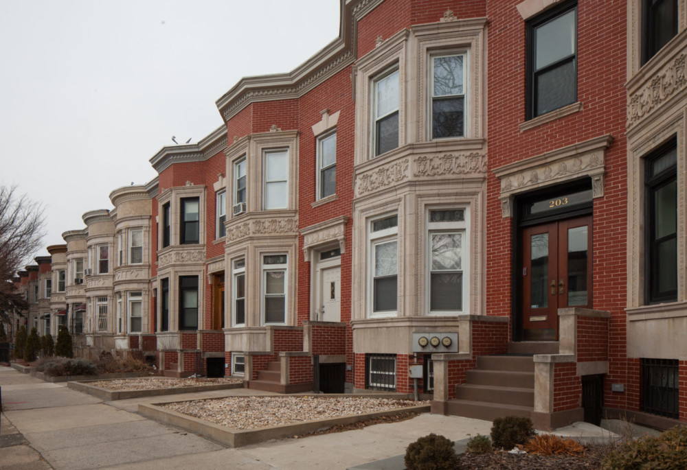
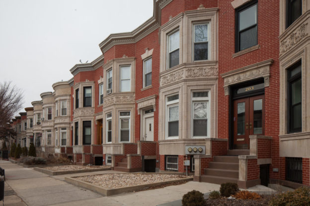
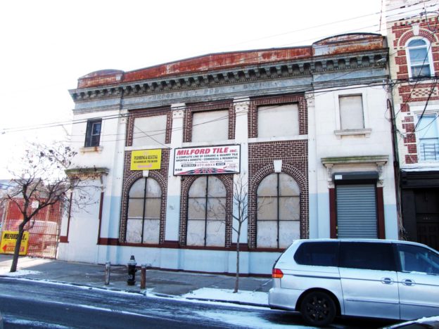
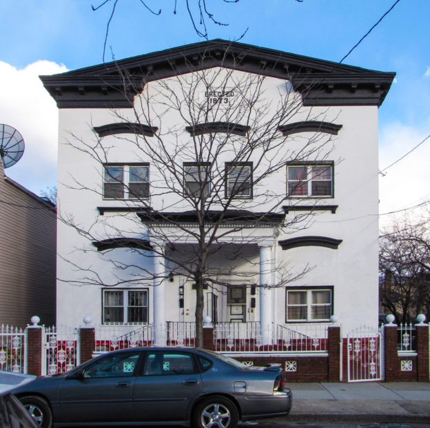
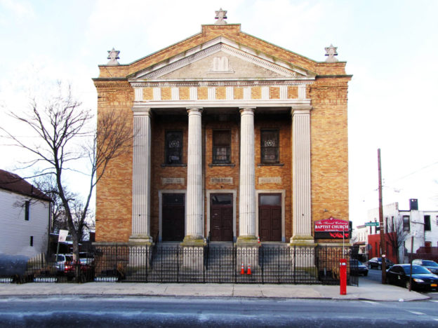
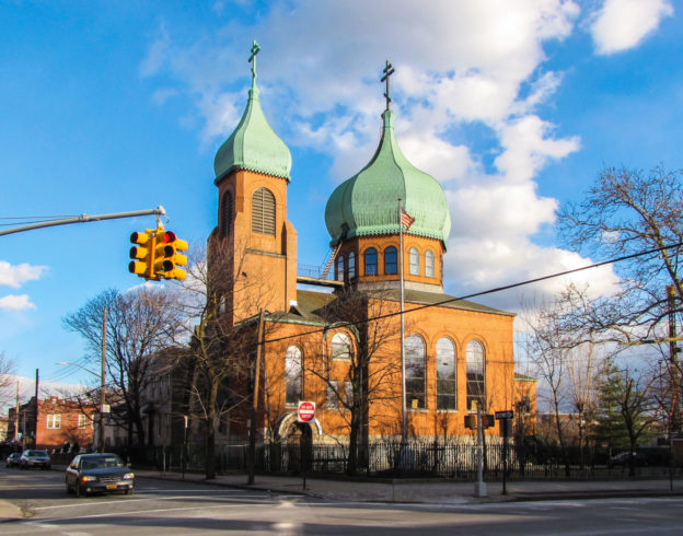
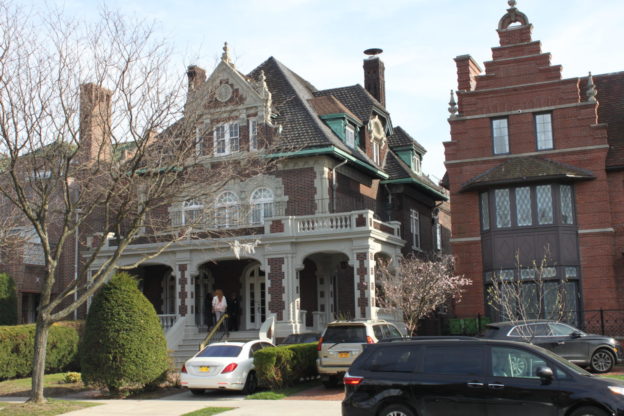
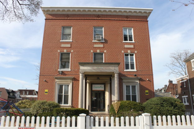
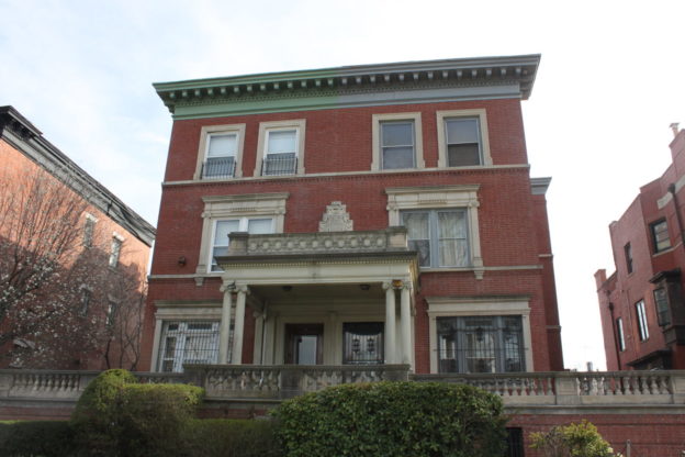
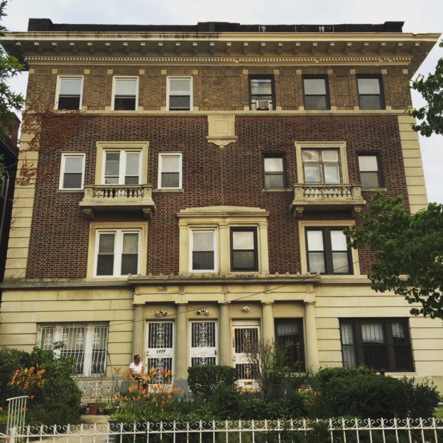
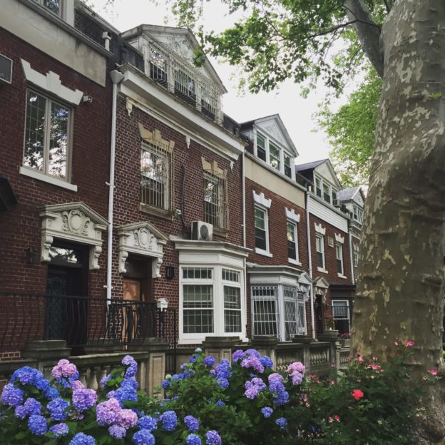
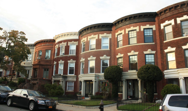
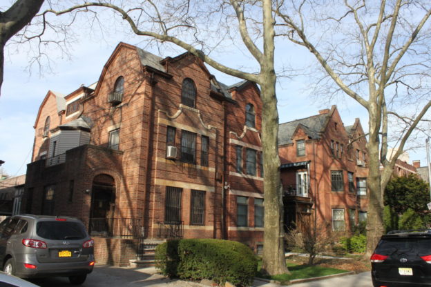
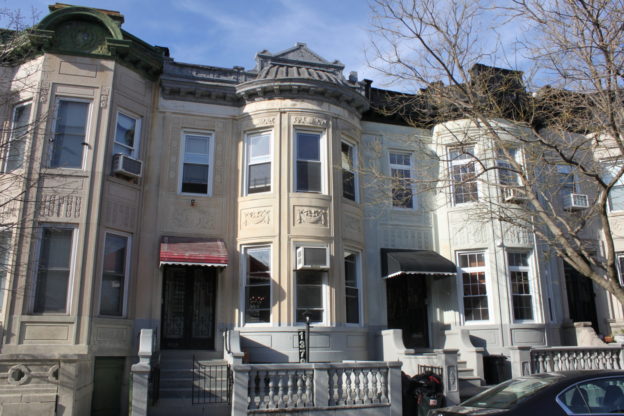
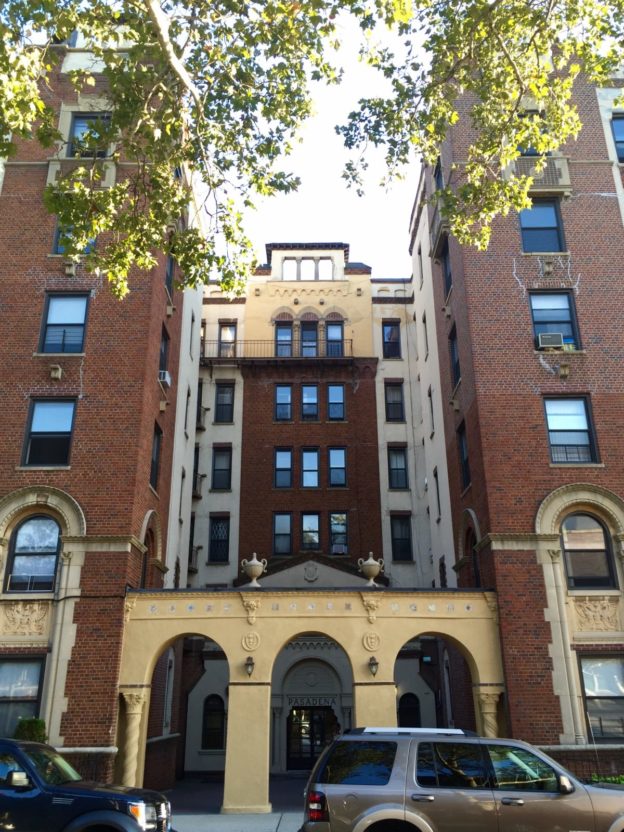
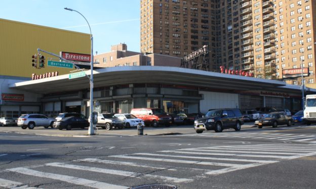
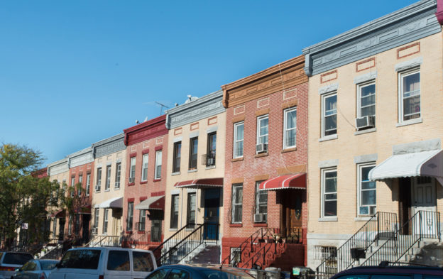
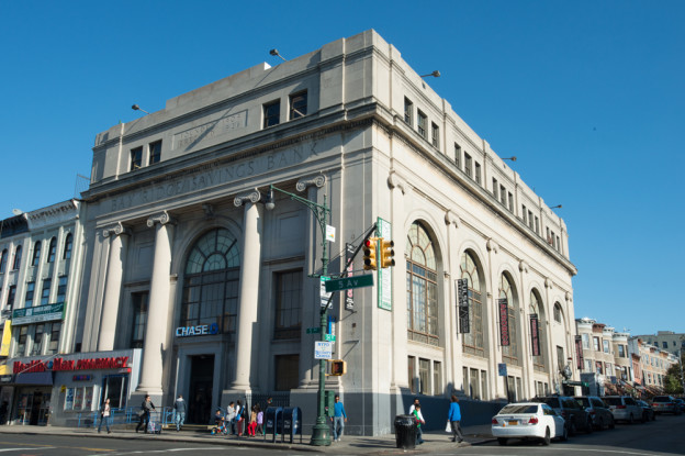
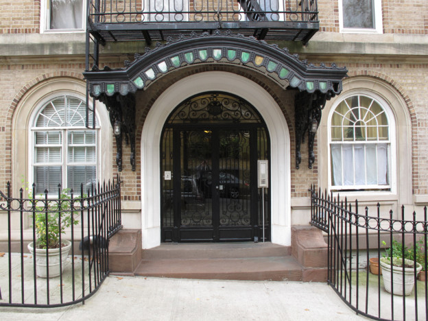
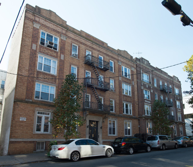
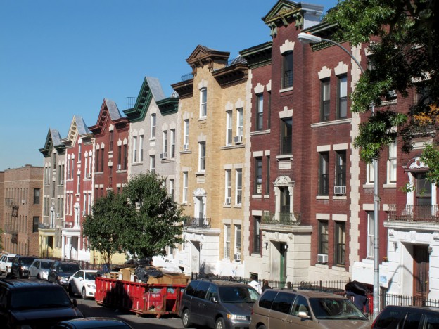
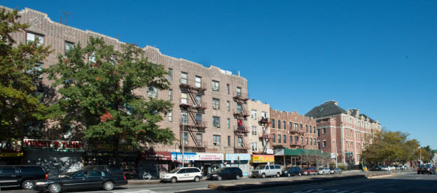
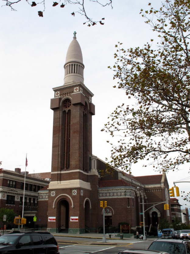
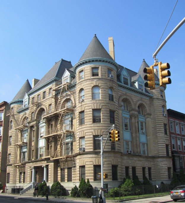
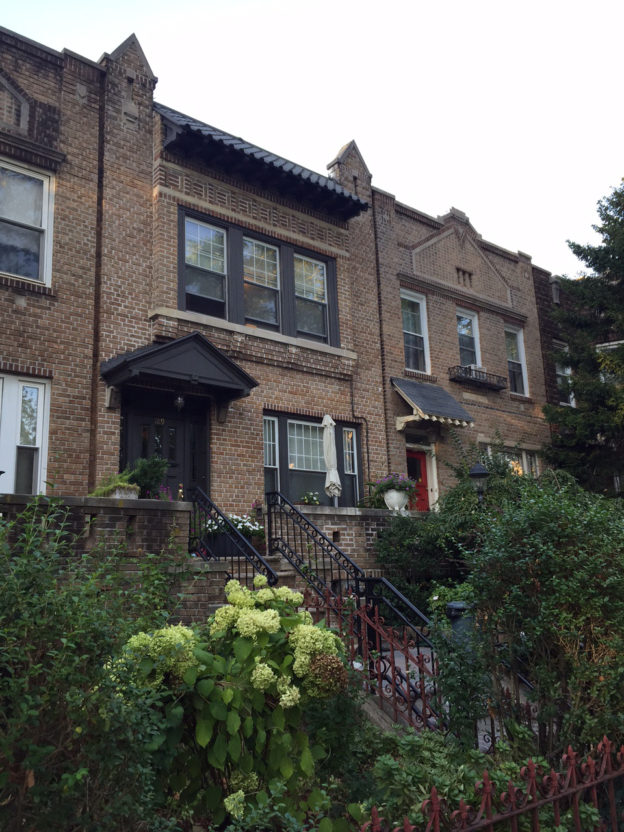
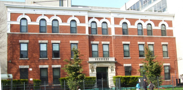
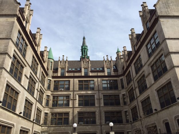
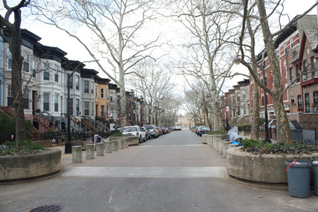
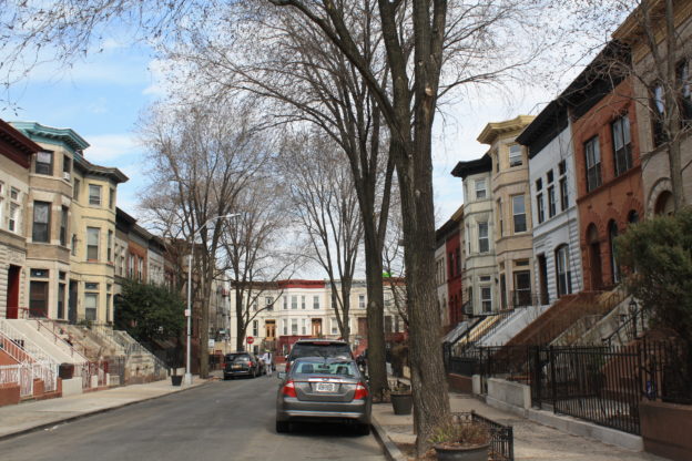
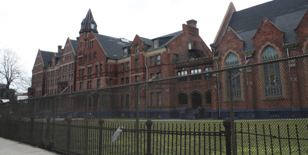
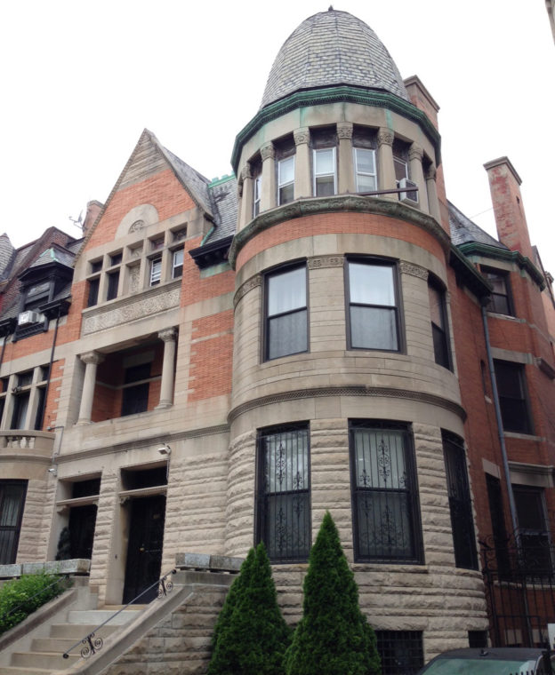
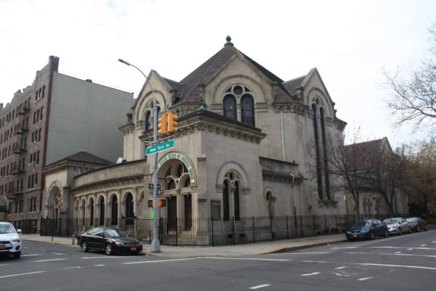
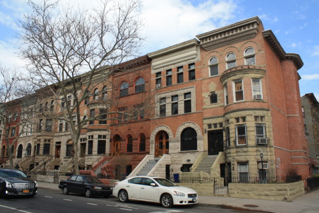
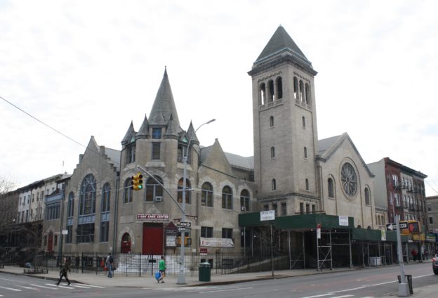
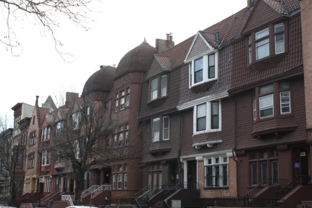
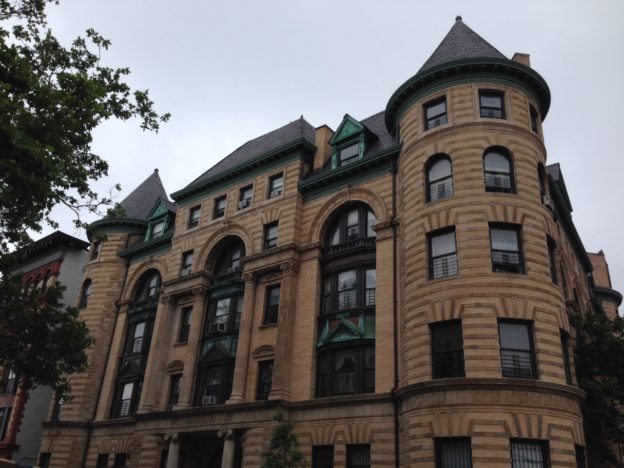
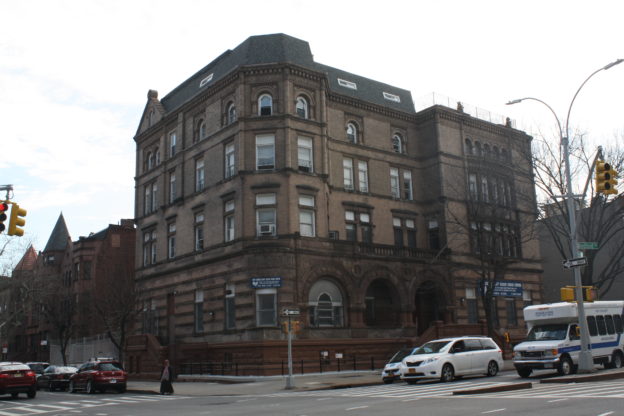
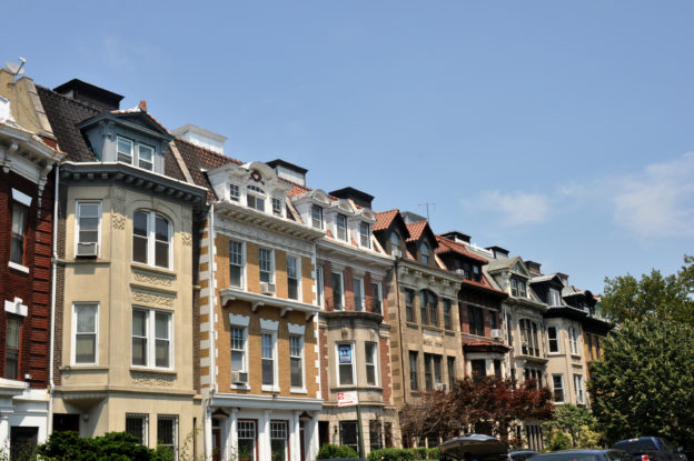
Several major changes led to the development of Crown Heights South after the turn of the 20th century. These included the 1907 demolition of the infamous Kings County Penitentiary, which was replaced by a Jesuit Prep school and college; the 1913 construction of Ebbets Field, home to the Brooklyn Dodgers baseball team; the development of Brooklyn’s famous Automobile Row, with its showrooms and service centers, which flourished on Bedford Avenue between 1905 and 1945; and the presence of the nearby Brooklyn Museum, which opened in 1897. Encouraged by these developments, as well as the new subways constructed under Eastern Parkway, developers built up entire blocks at a time with new housing. With the exception of certain blocks of single-family mansions, much of what was built was designed for multiple families, as the age of the single-family rowhouse had nearly passed. Crown Heights South displays a fine array of architectural styles of the early 20th century, designed by such prominent Brooklyn architects as Montrose W. Morris, Axel Hedman, J. L. Brush, Arthur Koch and Slee & Bryson in the Revival styles popular at the time: Renaissance, Colonial, Flemish, Tudor and more.

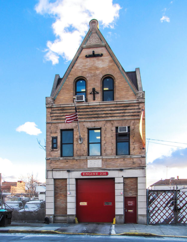
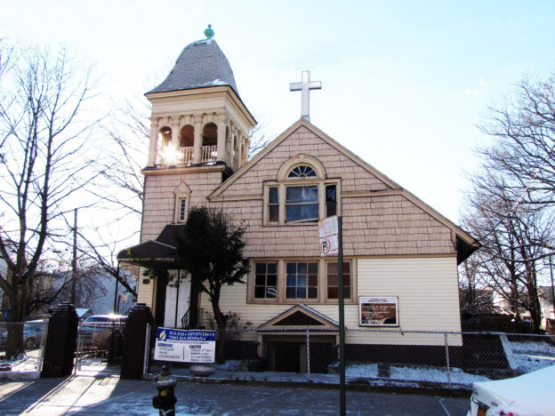
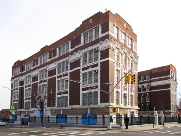
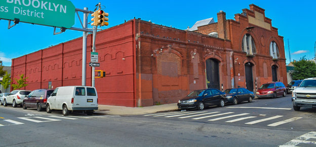
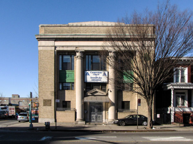
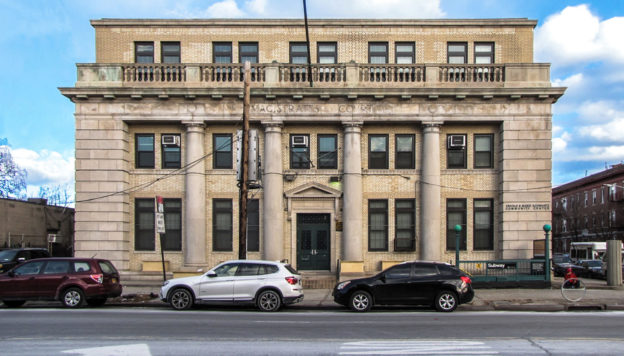
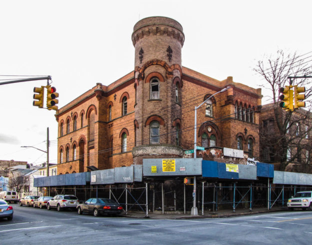
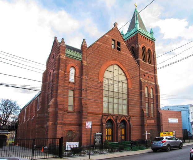
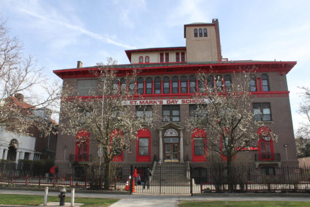
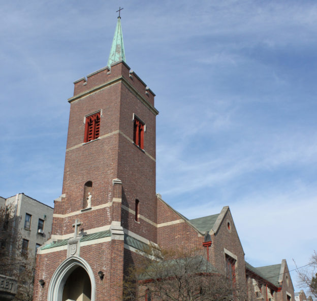
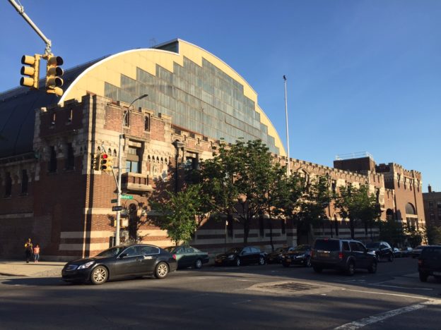
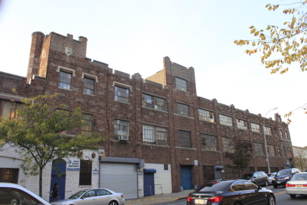
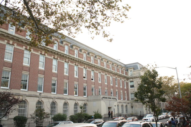
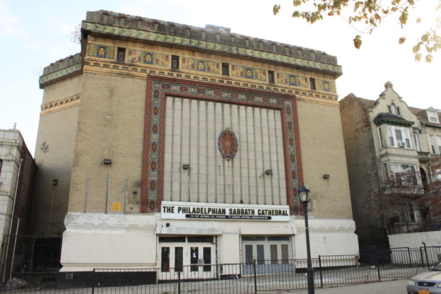
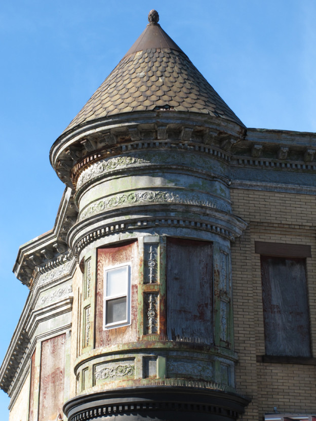
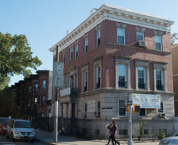
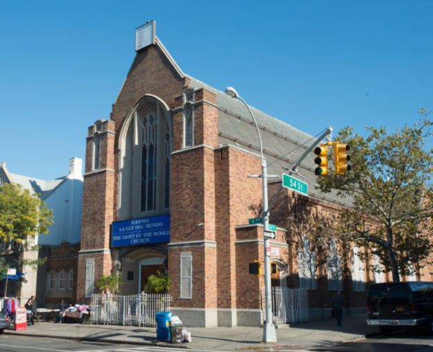
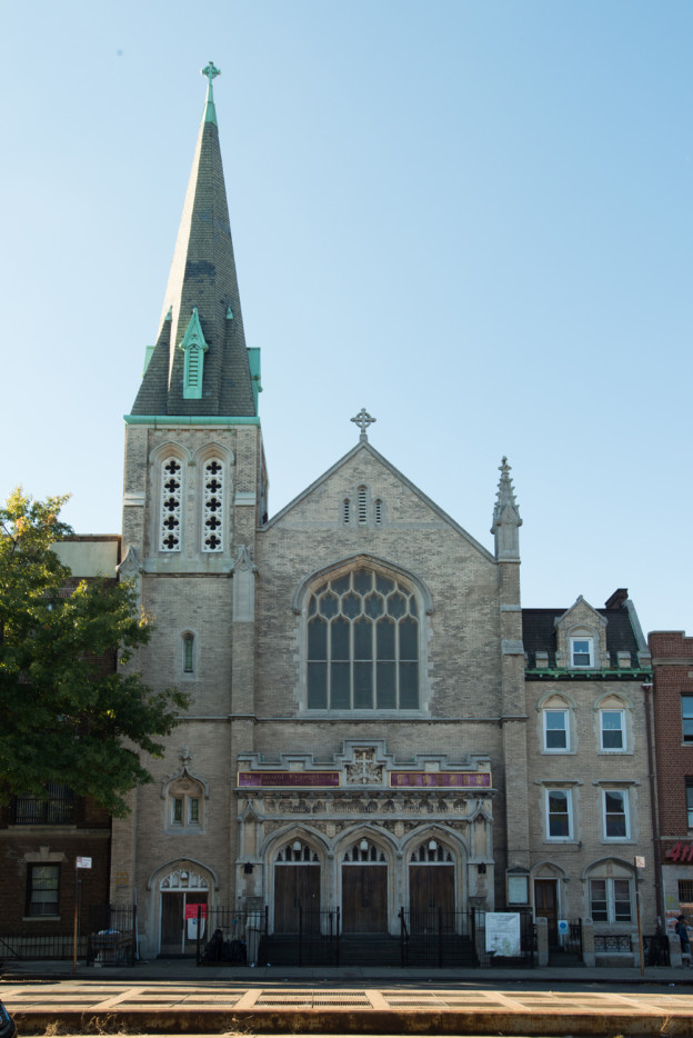
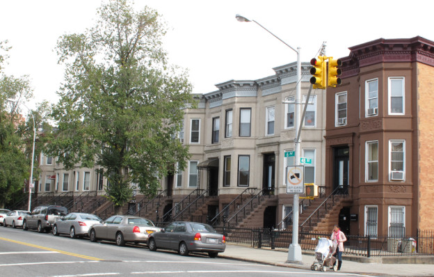
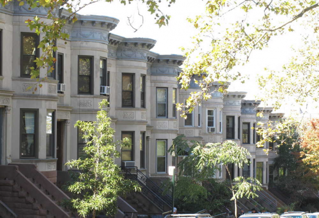
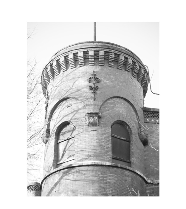
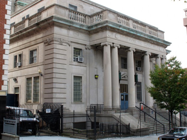
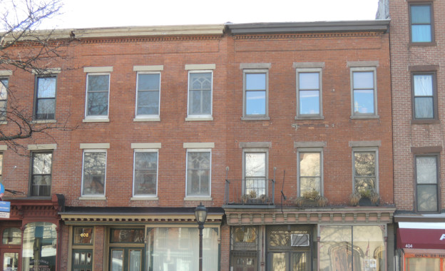
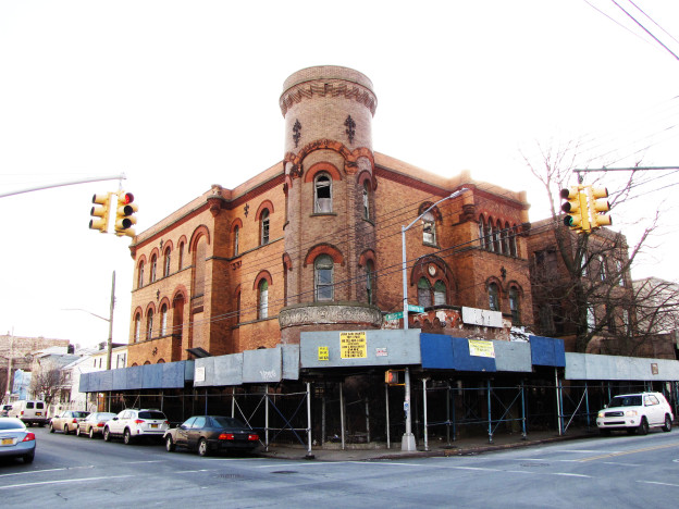
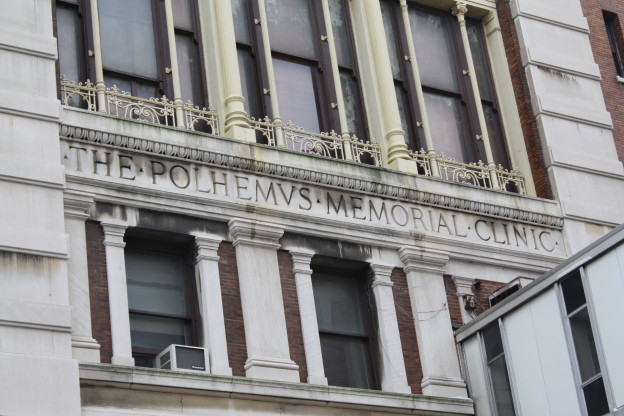
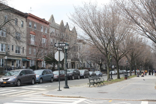
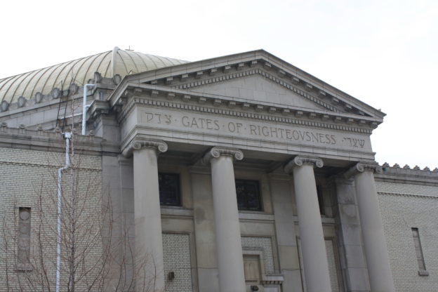
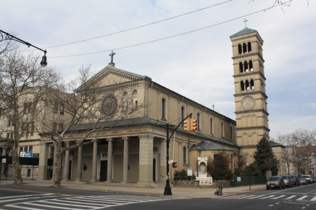
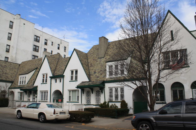
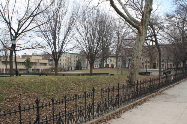
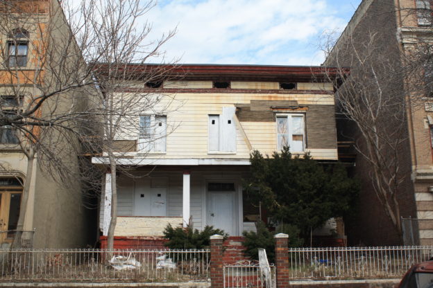
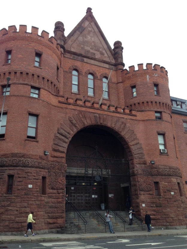
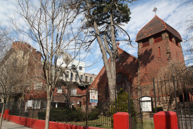
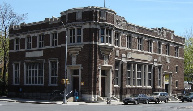
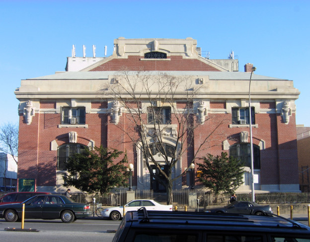
Today, the neighborhood retains its vibrant mix of residential architecture, including attached rowhouses, detached mansions and grand apartment buildings, as well as some fine religious buildings and grand institutions. One of its most well-known structures is the Bedford Armory, the city’s first mounted cavalry-unit armory that occupies an entire city block. The armory’s future is a source of controversy, with developers seeking to construct housing on the site and community members vying to preserve the building. Unfortunately, none of Crown Heights South’s architectural gems have been designated as landmarks by the New York City Landmarks Preservation Commission. Local advocates, including the Crown Heights South Association, formed in 2016, are working to survey and advocate for the neighborhood to ensure that any future changes are sensitive to its rich past.

Crown Heights North, Brooklyn

From farmland before the 1850’s, Crown Heights grew into one of Brooklyn’s most architecturally distinguished neighborhoods within less than 50 years and was recognized with historic-district designation in 2007. Originally part of Bedford-Stuyvesant and known as Bedford, it adopted the name “Crown Heights” in the mid-20th century. Today it is strongly Caribbean- and African-American with a growing white population.

To learn more about Crown Heights North click here

East New York, Brooklyn

East New York is a dynamic and largely unrecognized jewel in New York City. In the mid-17th century, Dutch farming families began migrating here from the town of Flatbush, referring to the land as the “new lots,” and it was soon identified as a subsidiary of Flatbush. In 1852, residents deemed themselves independent and began to refer to the community officially as New Lots. Present-day East New York is part of what was once the town of New Lots. In 1886, New Lots was annexed to help form the city of Brooklyn, and in 1898, was annexed again when Brooklyn and the other boroughs were consolidated to become the City of Greater New York.

In 1835, developers began buying farms in New Lots and laying out streets and lots. The area was prime for development due to the presence of the Jamaica Turnpike and the Long Island Railroad tracks along Atlantic Avenue. It was also a well-known destination for its two horse racing tracks, Union Course and Centerville Race Track (both demolished). The area’s most influential developer was a Connecticut merchant named John Pitkin, who purchased 135 acres and named his neighborhood East New York. The renaming was not only to set it apart for real estate purposes, but Pitkin envisioned a world-class and impressively-designed community filled with factories, shops and housing to rival New York City – an illustrious goal. Although Pitkin experienced significant losses during the financial panic of 1837, sales picked up in the mid-19th century and East New York became a thriving community even before neighborhoods much closer to Manhattan had even begun to be developed. Transportation improvements in the 1880s, including the opening of the Brooklyn Bridge and the introduction of steam cars and the elevated railroad on Atlantic Avenue, led to a building boom in East New York. Immigrants, including Germans, Italians, Russians and Eastern Europeans, migrated from crowded Manhattan neighborhoods to settle in the East New York countryside, in hopes of building a community where they would be free to communicate in their native languages, congregate and worship, patronize businesses catering to their cultural tastes and provide their children with opportunities to become skilled and educated citizens.

By the 1930s, East New York was widely regarded as a stable, working class community, boasting of great housing stock, schools and low crime. After World War II, however, the neighborhood unfortunately experienced a slow decline that it is still recovering from today. After the war, the city lost a great number of manufacturing jobs at the same time as large numbers of Puerto Ricans and African Americans were arriving in the city seeking employment. East New York was hit particularly hard in the 1970s by the FHA Mortgage Scandal and the unscrupulous and racially-charged real estate practice of “blockbusting,” which resulted in home foreclosure and abandonment. Unemployment, drug abuse and crime became commonplace in East New York, and its notorious reputation unfortunately lingers today. In recent years, East New York has begun to experience a rebirth. Vacant lots have been transformed into community gardens; well-maintained homes have helped to revitalize blocks; desolate sections under the elevated train tracks now exhibit vibrant murals; and diverse groups are working to enhance the neighborhood. One of these is Preserving East New York, a grassroots preservation group that formed to protect the neighborhood’s historic resources and illuminate its 300-year narrative of refuge, expansion, battle and rebirth. The group is advocating for landmark designation of some of the area’s historic buildings, an effort mainly spurred by the city’s announcement in 2015 that East New York would be rezoned for increased density as part of Mayor Bill de Blasio’s Housing New York plan.

Former Long Island College Hospital campus

70 Atlantic Avenue (Ferrenz & Taylor, 1974)
350 Hicks Street (Ferrenz & Taylor, 1984)
100 Amity Street, a.k.a. 350 Henry Street (Marshall Emery, 1896-97)
110 Amity Street (William C. Hough, 1902) |

On the south side of Atlantic Avenue is the northern tip of the Long Island College Hospital campus. The hospital opened in 1858, followed by the medical college in 1860. The distinguished institution was a trailblazer in its early years as the first in the country to employ bedside teaching and the first to provide an ambulance service in Brooklyn. The hospital served as a medical base for the Union Army during the Civil War, and treated sick immigrants after a fire at Ellis Island around the turn of the 20th century. In 1954, the hospital merged with the State University of New York and enjoyed several decades of renowned success. By the 1990s, the hospital was plagued with budget issues, and after many lawsuits, real estate deals and protests on the part of hospital workers, local residents and politicians, the institution finally closed in 2014. Plans are underway for mixed-use redevelopment. Two large-scale buildings are located on Atlantic Avenue: the E. M. Fuller Pavilion at 70 Atlantic Avenue and the Joan Osborn Polak Pavilion at 350 Hicks Street. Two late 19th and early 20th century hospital buildings are extant just south of Atlantic Avenue: the Polhemus Memorial Clinic at 100 Amity Street and the Dudley Memorial at 110 Amity Street. The former was a gift from Caroline Herriman Polhemus in honor of her husband, Henry Ditmas Polhemus, a regent of the hospital and a well-known figure in Brooklyn. It was built as a clinic to serve underprivileged people in the area, as well as provide laboratories and lecture rooms for the college. The latter was a gift from Henry W. Maxwell in honor of the hospital’s first Council member, Dr. William H. Dudley, and designed as a residence for student nurses. Both buildings were designed in the French Renaissance Revival style, making for a fanciful and exuberant display at the corner of Henry Street. All the buildings are located in the Cobble Hill Historic District.


Former Public School 109

215 East 99th Street;
Charles B. J. Snyder, 1899;
conversion: Hamilton Houston Lownie Architects and Victor Morales Architects 2015|

Public School 109 was designed by C. B. J. Snyder, superintendent of school buildings for the Board of Education from 1891 to 1923. Roughly 400 schools were constructed during his tenure, when the city’s population was growing and new laws mandated children’s education. Snyder was a great innovator, incorporating advances in fireproofing and air circulation, as well as laying out buildings in an H-plan, like P.S. 109, to increase light and air to classrooms and provide opportunities for recreation. With its many decorative details, the Collegiate Gothic style building is a great example of Snyder’s emphasis on the power of aesthetics in architecture. The school was decommissioned in 1995 and sat neglected for about 15 years until its restoration and conversion to artists’ housing. It reopened in 2015 as El Barrio’s Artspace/PS109, holding 89 units of affordable live/work space and 10,000 square feet for arts organizations. Artspace is a nonprofit that operates 35 arts facilities in 15 states.

The Former Public School 109 is listed on the State and National Register of Historic Places.

Eastern Parkway

Frederick Law Olmsted and Calvert Vaux;
1870-74
– Scenic Landmark|

Eastern Parkway, the world’s first six-lane parkway and one of only 10 scenic landmarks in New York City, was laid out by Frederick Law Olmsted and Calvert Vaux. The parkway, a term that Olmsted himself coined, featured broad green medians with rows of trees and paths for pedestrian and equestrian promenading. These medians were flanked on either side by service roads for carriages. Though it was narrowed over the years, the parkway retains this layout today. Eastern Parkway was designed to extend the picturesque character of Prospect Park, also by Olmsted and Vaux, eastward into the expanding residential neighborhoods of Brooklyn. It was also intended to encourage first-class residential construction, which was certainly a success in Crown Heights. Today, this “shaded green ribbon”, as Olmsted called it, forms the boundary between Crown Heights North and Crown Heights South.

Eastern Parkway is a New York City Scenic Landmark and located in the State and National Register of Historic Places Crown Heights North Historic District.

“Superblocks”

I.M. Pei and M. Paul Friedberg/Bedford Stuyvesant Restoration Corporation;
1966-69|

In 1966, the Bedford Stuyvesant Restoration Corporation (BSRC), formed and funded through legislation by Senators Robert F. Kennedy and Jacob Javits, began planning for an urban renewal initiative on two blocks in Crown Heights North. The two “superblocks” on Prospect Place and St. Marks Avenue were envisioned as a way to break the monotonous street grid and provide opportunities for recreation, respite, and an improved pedestrian experience. On Prospect Place, the sidewalks were widened and intersections were narrowed to slow vehicular traffic. More trees were planted and street furniture was added to create a serene environment. By contrast, St. Marks Avenue, an already wide street with a history as a play space, was blocked off to traffic in the middle with the creation of a mid-block park, complete with a fountain, wading pool, and furniture. The superblocks were the pilot project of the BSRC, and were deemed a success, fostering the formation of community maintenance groups, brownstone restoration, and increased real estate values.

These two “superblocks” run through the Crown Heights North, Crown Heights North II and Crown Heights North III Historic Districts.

Revere Place, Hampton Place and Virginia Place

Albert E. White, 1897;
Irving B. Ells, 1899-1902|

Short, mid-block streets inserted into the existing street grid, usually called “places” for through streets and “courts” for dead-end streets, were constructed in Brooklyn beginning in the late 19th century. The construction of these mid-block streets allowed developers to fit more houses onto a smaller parcel and created private enclaves desirable for home buyers. These three feature picturesque rows of houses of varied heights, many of which are lower rise than the rest of Crown Heights North. Revere Place, the earliest of the three, features houses in the Romanesque Revival and Renaissance Revival styles, while the houses on Hampton Place and Virginia Place were designed in the Colonial Revival style, perhaps to evoke their street names. The novelist Richard Wright and his wife Ellen lived at 11 Revere Place in 1941-42, when the neighborhood began to shift to a majority African- and Caribbean-American population.

Revere Place, Hampton Place and Virginia Place are all located within the Crown Heights North III Historic District.

Former Shaari Zedek Synagogue

221 Kingston Avenue ;
Eisendrath & Horowitz, 1923-25|

Formed in 1902 and originally located in Bedford-Stuyvesant, the Shaari Zedek Synagogue relocated here after the congregation merged with the Brooklyn Synagogue of Eastern Parkway in 1922. The synagogue and community house were completed in 1925 to the designs of Eisendrath & Horowitz, who had also been responsible for Temple Beth Elohim in Park Slope, Temple Beth Emeth in Prospect Park South, and Temple B’nai Israel in Sunset Park. All of these, like Shaari Zedek, were designed in the Colonial Revival style, which was popular for American synagogues in the early 20th century. The limestone and light grey brick building features a grand entrance portico with Ionic columns, a triangular pediment, and an entablature that reads “Gates of Righteousness,” the English translation of “Shaari Zedek.” An impressive standing-seam metal, octagonal dome sits atop the structure. When it was completed, the synagogue bore the distinction of housing the city’s largest Conservative Jewish congregation. In 1969, the building was sold to the First Church of God in Christ of Brooklyn.

The Former Shaari Zedek Synagogue is located in the Crown Heights North III Historic District.

Roman Catholic Church of St. Gregory the Great, St. Gregory the Great School, St. Gregory the Great Rectory

999 St. John’s Place;
Frank J. Helmle, 1915-16;
991 St. John’s Place;
Helmle & Corbett, 1921;
224 Brooklyn Avenue;
Helmle & Corbett, 1922|

This magnificent church has a strong presence in the neighborhood due to its richly decorated, seven-story campanile. Frank J. Helmle, was a prominent Brooklyn architect who also designed the Prospect Park Boathouse (1905), the Shelter Pavilion in Monsignor McGolrick Park (1910), and the Brooklyn Central Office, Bureau of Fire Communications (1913). Harvey Wiley Corbett, with whom Helmle collaborated on the church’s school and rectory, is well-known for his work in developing designs for setback, streamlined skyscrapers. The design of St. Gregory is inspired by Rome’s oldest basilicas, the fifth-century San Clemente and Santa Maria in Trastevere. While its bell tower dominates the rear of the church, the front is graced with a portico entrance of Ionic columns topped by a setback story that features a wheel window and shell niches housing sculpted figures. The school and rectory are far simpler, designed in the neo-Classical style to complement the church.

The Roman Catholic Church of St. Gregory the Great complex is located in the Crown Heights North Historic District and the State and National Register of Historic Places Crown Heights North III Historic District.

Former Brooklyn Methodist Episcopal Church Home for the Aged and the Infirm

920 Park Place;
Mercein Thomas;
1888-89; extension: William Kennedy, 1911-13|

Perhaps the most unusual and picturesque site in Crown Heights North is the former Methodist Home for the Aged, an enormous freestanding complex. Originally located in Bedford-Stuyvesant and established in 1883, the institution was founded by the Methodist Church in Brooklyn to provide housing and care for its elderly parishioners. As the original structure quickly became too small, this grand building was constructed in the Romanesque Revival style just five years later. A new wing and Gothic Revival style chapel were added in 1911-13. The home, evolving into a nursing facility, moved again in 1976 to a more modern structure, and this building was left abandoned for several decades. Today, part of the complex is operated by the Hebron French Speaking 7th Day Adventist School, a bi-lingual elementary school, but much of the complex is in a state of disrepair. This is a sad situation for an important building that stands not only as a beautiful architectural tableau, but as one of the few institutional buildings left in Crown Heights, which was once home to a large number of hospitals, asylums and homes for indigent populations.

The Former Brooklyn Methodist Episcopal Church Home for the Aged and the Infirm is located in the Crown Heights North II Historic District and the State and National Register of Historic Places Crown Heights North Historic District.

935-947 Prospect Place, 907-933 Prospect Place

A. White Pierce, 1920-22;
Matthew W. Del Gaudio, 1933-36|

This row of six Arts and Crafts style stucco houses was built in the early 1920s, just as the automobile was gaining traction, as evidenced by the three narrow archways that lead to attached garages in the rear. Architect A. White Pierce was known for his work on suburban residential architecture, including many houses in Prospect Park South and Ditmas Park. True to his specialty, these six lovely houses were designed in a human-scale, with charming touches like steeply pitched gables, dormers, arched openings, and a sloped slate roof that unifies the row. Next door, a much different kind of housing is found at 907-933 Prospect Place, a grand Art Deco style apartment building adorned with colorful, geometrick brickwork.

935-947 Prospect Place and 907-933 Prospect Place are located in the State and National Register of Historic Places Crown Heights North Historic District.

Brower Park

 est. 1892|

Crown Heights North’s only public park was established in 1892, when the City of Brooklyn purchased what is now the southern portion and named it Bedford Park. The northern portion was acquired in 1923, the same year the park was renamed for former Parks Commissioner George V. Brower, who died in 1921. Brower was a strong parks advocate who was instrumental in creating many parks in Brooklyn, including Sunset, Red Hook, and Fort Hamilton Parks. A resident of the neighborhood, Brower loved Bedford Park, and even built his mansion at the corner of Park Place and Kingston Avenue (it was later replaced by the Shaari Zedek Synagogue, site # 18). The park’s classically-inspired comfort station was built in 1905, and a World War I memorial was erected in 1919. In 1936, drinking fountains and a playground were added and paths were reconfigured. The park was extended in 1947 to include the portion between Prospect Place and St. Marks Avenue, including land for the George V. Brower Elementary School. The school opened in 1958, at which time the portion of Prospect Place that ran through the park was grassed in. The Friends of Brower Park formed in 2009 to care for the park.

Brooklyn Children’s Museum

145 Brooklyn Avenue;
Hardy Holzman Pfeiffer Associates;

1977; expansion: Rafael Viñoly, 2008|

Despite the Brooklyn Children’s Museum’s contemporary design, the institution itself is believed to be the oldest children’s museum in the country. It has been located on this site since 1899, when a mansion on this property – the William Newton Adams House – was converted into a children’s museum. It proved to be a huge hit, so at some point over the next two decades, the museum expanded into the L.C. Smith House next door. By 1967, the museum had outgrown both mansions and began planning for a new building on the site, which was completed in 1977. The current iteration of the Brooklyn Children’s Museum was mostly constructed in 2008, but its design is in fact an expansion of the 1977 structure, which was largely subterranean. The expansion, whose wavy design and primary color palette are in stark contrast to the character of the surrounding neighborhood, is clad in 8.1 million yellow ceramic tiles. The expansion roughly doubled the building’s size to 102,000 square feet.

789 St. Marks Avenue, 805 St. Marks Avenue, 828-838 St. Marks Avenue, 839 St. Marks Avenue, 855-857 St. Marks Avenue, 889 St. Marks Avenue

Slee & Bryson, 1919-20;
Russell Sturgis, 1869-70;
Montrose W. Morris, 1892;
Peter J. Lauritzen, 1898-1903|

St. Marks Avenue between New York and Kingston Avenues is home to a number of interesting structures. Beginning in the 1890s, the avenue was considered one of the wealthiest in Brooklyn and certainly the most fashionable in this area. The avenue had a number of freestanding mansions set in landscaped gardens, as well as nice groupings of attached rowhouses. While most of the freestanding mansions were demolished to make way for middle class housing with the arrival of the subway in the early 20th century, one of the most impressive mansions survives at number 839. Originally the home of lumber dealer Dean Sage, the rock-faced brownstone mansion was designed in the High Victorian Gothic style and features wrought iron and terra cotta trim. The house originally had a large front porch, which was removed in the 1930s, when the house was converted to an institution for the developmentally disabled. Number 889 is notable for its grand Beaux-Arts style.

Each site is located in the Crown Heights North Historic District and the State and National Register of Historic Places Crown Heights North Historic District.

Former George B. and Susan Elkins House

1375 Dean Street;
c. 1855-69 |

This lovely wood-frame house with Greek Revival and Italianate details stands as a reminder of the early development of Crown Heights North, when freestanding villas were built during the neighborhood’s transition from farmland in the mid-19th century. George Elkins was a real estate developer specializing in the sale of sites similar to this one in this burgeoning commuter suburb.

The Former George B. and Susan Elkins House is a New York City Individual Landmark, located in the Crown Heights North Historic District and the State and National Register of Historic Places Crown Heights North Historic District.

StuyPark House

77 New York Avenue;
John Louis Wilson, Jr., 1975|

While not a particularly distinguished architectural contribution to the neighborhood on first glance, Stuy Park House, a senior housing complex, holds an important cultural significance to Crown Heights North. Its architect, John Louis Wilson, Jr., was the first black architect to graduate from the Columbia University School of Architecture. Throughout his 50-year career, he served as a mentor to black architects, helping many to get their start in the field. In the mid-1950s, he founded the Council for Advancement of Negroes in Architecture, which eventually merged with the American Institute of Architects (AIA). In 1984, the AIA honored Wilson with the Whitney M. Young Jr. citation. His most famous work was the Harlem River Houses at 151st Street and the Harlem River Drive in Manhattan, the first federally financed housing project, completed in 1937.

Union United Methodist Church, School and Parsonage

121 New York Avenue;
Josiah C. Cady & Co., 1889-91|

This monumental building was originally constructed for the New York Avenue Methodist Episcopal Church. Its Romanesque Revival style design was the work of Josiah Cady, who was known for his use of the style, especially for churches, but which he also famously employed for the south wing of the American Museum of Natural History. The red brick and sandstone church does not feature a lot of ornament, but its solid and complex massing, arched openings, and detailed brickwork are masterfully arranged. Its tower was intended to have a pyramidal roof, but was never completed. The tower was designed with an elaborate air ventilation system, whereby fresh air was drawn through pipes and ducts to cool the building in the summer and warm air from the furnace was funneled upward to warm the building in the winter. The basement once contained a bowling alley.

The Union United Methodist Church, School and Parsonage are located in the Crown Heights North Historic District and the State and National Register of Historic Places Crown Heights North Historic District.

Hebron French Speaking Seventh Day Adventist Church

100 New York Avenue;
Henry Ives Cobb, 1909-10|

This striking church is the area’s only example of neo-Byzantine style architecture. It features unusual massing, an octagonal sanctuary, a pyramidal roof, round arch openings, identical entrance pavilions on New York Avenue connected by a curving, blind arcade, and intricate stained glass with floral and figural motifs. Originally constructed for the First Church of Christ Scientist, it was designed by noted Chicago architect Henry Ives Cobb, who was famous for his design of the Fisheries Building at the World’s Columbian Exposition in 1893.

The Hebron French Speaking Seventh Day Adventist Church is located in the Crown Heights North Historic District and the State and National Register of Historic Places Crown Heights North Historic District.

1217-1235 and 1247-1265 Dean Street

Albert E. White;
1891-92|

On the north side of Dean Street between Nostrand and New York Avenues is a fine collection of 20 Romanesque Revival style rowhouses, all designed by the same architect for upper middle class families. The colorful and remarkably intact houses are arranged in groups of five, and feature textured stonework and round arched window openings.

1217-1235 and 1247-1265 Dean Street are located in the Crown Heights North Historic District and the State and National Register of Historic Places Crown Heights North Historic District.

Bedford Presbyterian Church

1200 Dean Street;
Arthur Bates Jennings, c. 1897;
expansion: Dodge & Morrison with Kenneth M. Murchison, 1906
– NYC HD, NR-D|

This Romanesque Revival style church was completed in two phases about 10 years apart by different architects. The northern section facing Dean Street is the original building, while that facing Nostrand Avenue was added later. The church dominates the intersection with its romantic massing, including gables, conical and pyramidal turrets, and a campanile bell tower, as well as decorative features like round arches with rough-faced stone lintels, leaded glass windows, and slate tile roof. The church retains the neighborhood’s original name, Bedford.

The Bedford Presbyterian Church is located in the Crown Heights North Historic District and the State and National Register Crown Heights North Historic District.

1146-1150 Dean Street, The Granleden Apartments, 1164-1182 Dean Street

George P. Chappell, 1891;
1149-1153 and 1155-1157 Dean Street;
Axel Hedman, 1906;

1164-1182 Dean Street;
George P. Chappell, 1889|

1146-1150 Dean Street is unusual for the architectural character of Crown Heights North. The Renaissance Revival style buildings are bold in their horizontality, with unified cornice lines above the first floor and roof, thin rows of rough-faced brick with terra cotta bands at every fourth course, and horizontal striations at the parlor floor. The trio is arranged in an A-B-A pattern, but is not symmetrical, which is most apparent in the placement of the stoops. Across the street is a pair of flats buildings called The Granleden Apartments. Constructed in the early 20th century when multiple dwellings were becoming more popular and economically beneficial, each building has eight apartments (two per floor). Its rich Renaissance Revival style façades have retained much of their original terra cotta ornament, as well as their fanciful bronze grille doors and wrought iron fire escapes. Further down the block is an unusual group of ten houses in a variety of material textures and rooflines, including Flemish stepped gables on the far ends and prominent mansard roofs in the center.

Each site is located in the Crown Heights North Historic District and the State and National Register of Historic Places Crown Heights North Historic District.

Former 23rd Regiment Armory

1322 Bedford Avenue;
Fowler & Hough and Isaac Perry, 1891-95|

This grand, fortress-like structure was constructed by the State of New York for Brooklyn’s 23rd Regiment, which formed in the 1860s and served briefly in the Civil War. This was the regiment’s second home, after it outgrew its first armory on Clermont Street, built in 1872-73. The armory was used to train soldiers and store equipment, but also as a military club for soldiers and veterans, so in addition to a vast drill hall, the interior also had a library, company rooms, and dining rooms. The imposing brick, stone, and terra cotta exterior has eight crenellated towers, the tallest of which rises to 136 feet. The main entrance on Bedford Avenue is located within a rusticated round archway with a decorative iron gate. Terra cotta friezes display the regimental motto and coat of arms. To the right of the entrance bay is a bronze plaque sculpted by J. Massey Rhind in 1922 to commemorate the regiment’s sacrifices during World War I. In 1905, the vast drill hall was home to Brooklyn’s first automobile show, and in the mid-1920s, it was leased to William Randolph Hearst as a silent film studio. The armory remained in operation until 1982, when the building was converted to a men’s homeless shelter.

The Former 23rd Regiment Armory is a New York City Individual Landmark and listed on the State and National Register of Historic Places.

St. Bartholomew’s Church, Rectory, Parish House

1227 Pacific Street;
Church and rectory: George P. Chappell, 1886-90;
Parish house: Montrose Morris Sons, 1921|

Set back from Pacific Street by a low fence, wrought iron gate a front yard, St. Bartholomew’s Church was designed in the Arts and Crafts style and features a round-arched stained glass window designed by Tiffany Studios in 1930, making it one of the studio’s last commissions, and a large square tower and belfry. The church played a significant role as one of the venerable institutions near Grant Square catering to the area’s Episcopal population. While the church itself is an individual landmark, neither the rectory to the east nor the parish house to the west are designated. The rectory is believed to have been constructed at the same time by the same architect, while the neo-Gothic parish house was added in 1921.

St. Bartholomew’s Church is a New York City Individual Landmark and both the church and rectory are listed on the State and National Register of Historic Places.

The Imperial Apartments, The Bedfordshire Apartments

1198 Pacific Street and 1327-1339 Bedford Avenue;
Montrose W. Morris, 1892;

1200 Pacific Street;
Montrose W. Morris, 1891 |

These two striking apartment buildings were designed by Montrose W. Morris, one of the most prominent Brooklyn architects of his day. The Imperial resembles a French château, with Renaissance Revival style details that include grand arches supported by fluted Corinthian columns and pilasters, conical turrets, and a slate mansard roof. Its window bays are faced in copper, whose green patina forms a nice contrast to the Bedforshire’s brownstone ornament, which has more recently been painted red. The Bedfordshire also features grand arches supported by pilasters, and its top story is graced with small arches and a projecting cornice. The Imperial was considered to be the finest apartment building in Brooklyn when it opened, and was even compared to The Dakota in Manhattan. It fell into disrepair in the late 20th century and was boarded up until a major renovation and restoration in 2006 that revived the building’s status as a showpiece for Crown Heights North and converted it into affordable housing.

The Imperial Apartments are a New York City Individual Landmark, located within the Crown Heights North Historic District and on the State and National Register of Historic Places.

The Bedfordshire Apartments are located within the Crown Heights North Historic District and on the State and National Register of Historic Places.

Former Union League Club of Brooklyn, General Grant statue

19 Grant Square;
Peter J. Lauritzen, 1890;
William Ordway Partridge, 1896|

This handsome Romanesque Revival style building was constructed as a social club for the Union League, established in 1863 by Union supporters and members of Brooklyn’s Republican Party. The Grant Square façade abounds in Union iconography, most significantly in the brownstone busts of Abraham Lincoln and Ulysses S. Grant above the entrance arches and a grand eagle supporting the second floor bay window. The building’s rich terra cotta trim includes a plethora of Byzantine leaf, popular in the 1880s and 1890s. The structure’s roofline suffered major alterations in the 1970s, including the removal of Spanish tiles, a turreted observation tower, and a gabled roof with a large dormer. In the early 20th century, after the boroughs were consolidated, the club merged with the Manhattan branch. In 1914, the building became home to a Jewish organization called the Unity Club until 1943, and was subsequently converted to a Yeshiva. The building currently houses the Bhraggs Grant Square Senior Citizens’ Center. The Union League Club commissioned the bronze statue of Grant that sits within the adjacent square, and donated it to the city in 1896, when it was unveiled on Grant’s birthday.

The Former Union League Club of Brooklyn and General Grant statue are located within the Crown Heights North Historic District and State and National Register of Historic Places Crown Heights North Historic District.

Gowanus, Brooklyn

The Brooklyn community of Gowanus, centered around the Gowanus Canal, is largely made up of historic architecture directly related to the water route. Located between Park Slope and Carroll Gardens, it is considered part of Brooklyn’s industrial waterfront. The canal itself is 2.5 miles long, 100 feet wide, and stretches from Gowanus Bay in New York Harbor to Douglass Street. Unlike other industrial areas of the city, Gowanus was never densely built up, and much open space remains today. The structures that surround the canal are generally six stories or fewer, lending a low-scale, 19th-century character. This area continues to be mixed-use manufacturing with peripheral residential enclaves.

Historically one of New York’s most contaminated waterways, the Gowanus Canal area was designated as a Superfund Site in 2010. To protect the historic character of the neighborhood the local community is currently working to place the Gowanus Canal Corridor on the National Register of Historic Places so that its urban industrial character is preserved.

To learn more about Gowanus click here

Greenpoint, Brooklyn

Spurred by a period of economic growth and an influx of European immigrants during the 1850s, more than a dozen shipbuilding firms turned the neighborhood into a major shipbuilding center. While shipbuilding declined after the Civil War, Greenpoint’s other industrial enterprises, which included porcelain making, glass making, and oil refining, continued to thrive. Greenpoint’s residential development was closely aligned with its industrial growth, as workers’ housing was built inland from the waterfront. Large, elaborate rowhouses were constructed for owners and managers, while modest rowhouses, tenements, and apartment buildings were built for laborers. The neighborhood also boasts many fine churches and institutional buildings, such as the Greenpoint Savings Bank and the Mechanics and Traders Bank.

To learn more Greenpoint click here

Historic Public Libraries, New York City

The New York Public Library (NYPL) was formed in 1895 with the consolidation of three private corporations: the Astor Library (founded by John Jacob Astor in 1849), the Lenox Library (founded by James Lenox in 1870) and The Tilden Trust (a fund established in 1886 by Samuel J. Tilden). The NYFCL also joined this consolidation in 1901 in order to benefit from Carnegie’s gift of $5.2 million for 67 library branches to be built between 1901 and 1929 (56 are still standing). Carnegie’s only stipulation was that the city acquire the sites and establish building maintenance plans. To design the buildings, the NYPL organized a committee of architects: Charles F. McKim, Walter Cook and John M. Carrère. In order to stylistically link the branches and save money, the committee decided on a uniform scale, interior layout, character and materials palette for the buildings.

To read more about New York City’s Historic Public Libraries click here

Landmarks Under Consideration, New York City

In November 2014, the New York City Landmarks Preservation Commission (LPC) announced a plan to clear 95 properties that had been on its calendar for five years or more, but not yet designated as landmarks. The wholesale removal of these properties without considering each one’s merits would have represented a severe blow to the properties and to the city’s landmarks process in general, sending a message that would jeopardize any future effort to designate them.

The Historic Districts Council acted strongly in opposition to this action, and advocated for a more considered, fair and transparent approach. As part of this effort, HDC worked with Manhattan Borough President Gale Brewer and a coalition of other preservation organizations to submit an alternative plan for the LPC’s consideration. The plan eventually formed the basis for the LPC’s initiative, entitled “Backlog95,” calling for a series of public discussions to evaluate the properties in geographical groupings.

To learn more about the Landmarks Under Consideration click here

Prospect-Lefferts Gardens, Brooklyn

This neighborhood was once part of the Town of Flatbush, one of the original six towns established by Dutch and British Colonists in what is now Kings County. Flatbush remained an independent municipality until it was annexed in 1894 by the City of Brooklyn, which then became part of Greater New York in 1898. Up until this point, much of Flatbush was used for agricultural purposes. One of the largest landowners was the Lefferts family, which settled in Brooklyn in 1661. Various branches of the family maintained expansive farmsteads throughout Kings County, as well as in Queens, Long Island and New Jersey. The estate comprising much of Prospect Lefferts Gardens eventually passed to John Lefferts. An early proponent of development, he helped found the Flatbush Plank Road Company in 1855 to improve access to the area.

As was often the case in New York City, transportation was the primary catalyst for urban development in the neighborhood. Continuing his father’s efforts, John’s son James Lefferts invested in the Brooklyn, Flatbush & Coney Island Railway Company, established in 1878. Initially serving pleasure seekers traveling between the Flatbush Long Island Railroad terminal and the beach, this became a true commuter line in 1896 when it was extended northward to downtown Brooklyn and eventually crossed the Brooklyn Bridge to Manhattan in 1901. John Lefferts began to subdivide the estate in 1887 when he announced the sale of 516 lots east of Rogers Avenue. A promotional pamphlet proclaimed that, “the absurdity of devoting lands so desirable, central, and valuable to raising corn and potatoes has finally induced the owner to part with [the] lots.” The local press pronounced it “the most brilliant auction sale ever made in Flatbush,” which likely encouraged James Lefferts to put an additional 600 lots—most of the remaining farmstead—up for sale in 1893. Perhaps because these lots surrounded Lefferts’ own homestead, he added restrictive covenants prohibiting standard “noxious” uses (primarily industrial) and further stipulating that all buildings would be single-family houses. The lots covered by these covenants consisted of the area between Flatbush Avenue and Rogers Avenue from Lincoln Road to Fenimore Street, and was and is referred to as Lefferts Manor. In 1919 the Lefferts Manor Association was established to enforce the restrictions and preserve the area’s single-family residential character. Though the covenants limited use to single-family houses, the Association and the press were quick to point out that this did not overly restrict the neighborhood’s architectural variety. As one article noted, “the rule has not brought about any monotonous style of architecture. Some of the residences are of imposing size, in stone, stucco or wood. Others are dignified brick buildings in a row.” Outside Lefferts Manor, development was somewhat less constrained. Many blocks were built up with two-family row houses—some closely resembling their single-family counterparts and others more clearly embracing their duplex character. Some contain six-story elevator apartment buildings designed in a variety of styles. Flatbush Avenue in particular has a wealth of small-scale commercial buildings with fine architectural details.

By the 1960s the Association began to rely on zoning regulations to enforce the residential character of the neighborhood, and in the 1970s a portion of the neighborhood was designated as a New York City historic district to preserve its architectural character. The Prospect Lefferts Gardens Neighborhood Association was founded in the late 1960s to foster racial integration in the area and to promote the vitality of the greater neighborhood (both inside and outside Lefferts Manor), a goal shared by the many civic organizations that continue to advocate for the preservation of Prospect Lefferts Gardens.

Sunset Park, Brooklyn

Originally part of Bay Ridge, the area got its own name with the creation of Sunset Park in 1891. Today, the neighborhood extends from Prospect Expressway to 65th Street and Eighth Avenue to the waterfront. Sunset Park’s first major development began after the Civil War, when manufacturing enterprises were established on its waterfront. Beginning in the 1880s, the inland area developed as a residential.

Sunset Park’s standout building type is the masonry rowhouse. Mostly built between 1885 and 1912, these stunning blocks are accented by commercial thoroughfares and institutional and religious buildings mostly completed by the early 1930s. The neighborhood’s most pronounced architectural styles are neo-Grec, Romanesque Revival and Renaissance Revival, all popular at the end of the 19th century. In 1988, an area encompassing 3,237 buildings was listed on the National Register of Historic Places.Despite this designation, Sunset Park currently remains unprotected by local landmark status, aside from a few individual landmarks.

To learn more about Sunset Park click here

Victorian Flatbush, Brooklyn

Established as a Dutch farming village in 1652, Vlacke Bos, meaning “flat woodland” in Dutch, was later Anglicized to Flatbush. Around the time that it became part of the city of Brooklyn in 1894, Flatbush began its transformation into a residential suburb.Today, Victorian Flatbush is comprised of 11 neighborhoods that were all developed with the suburban country aesthetic as inspiration, which is still evident in the layout of the streetscapes with their yards, freestanding homes, and in some places planted street medians. While the houses were all constructed around the same time, their ornamental details were carefully selected to distinguish each from the other. Today this group of neighborhoods makes up one of the largest collections of Victorian-era wood-frame residential architecture in the country, though only roughly half are legally protected by the city as historic landmarks.

To learn more about Victorian Flatbush click here

Brownsville Branch, BPL and Stone Avenue Branch, BPL, Brooklyn

61 Glenmore Avenue Lord & Hewlett, 1908;
581 Mother Gaston Boulevard William B. Tubby, 1914;
NYC IL|

The simple, free-standing Brownsville Branch, today flanked by high-rise public housing, was once bounded by single-family residences. Before it opened, the neighborhood was growing so dramatically that the building had to be enlarged before it was completed. Due to overwhelming demand by local children, another site just six blocks to the south was purchased at Stone (now Mother Gaston Boulevard) and Dumont Avenues for the Brownsville Children’s Library. Stylistically divergent from the other Carnegie libraries, the Brownsville Children’s Library was designed in the Jacobethan style, rendering it a sort of hybrid between library and fairytale castle. It is said to be one of the world’s first public libraries devoted to children. The exterior features stone carvings depicting characters and scenes from children’s literature, while the interior embraces a child-appropriate scale and features beloved details, like rabbits carved into the wooden benches. After World War II, the library opened to all age groups, renaming itself the Stone Avenue Branch. The Stone Avenue branch was designated a New York City Individual Landmark in April 2015.

Park Slope Branch, BPL, Brooklyn

431 Sixth Avenue;
Raymond F. Almirall, 1905-06;
NYC IL|

This library was originally the Prospect Branch, housed beginning in 1900 in Prospect Park’s Litchfield Villa and consisting solely of books related to natural history. As Park Slope’s population grew, the demand for a larger, all-purpose library led to its relocation in 1901 to several storefronts on 9th Street between 5th and 6th Avenues. By 1904, the city purchased a large site and began planning for a new Carnegie-funded building. Its name was changed to Park Slope in 1975. The Classical Revival style, brick-clad building with limestone trim features an imposing, projecting portico entrance with Doric columns and a stone pediment. Like those found on the Pacific Branch, the torches in the keystones above the entrance and windows represent the light of learning. Its intact interior features stained glass, tiled fireplaces, wood paneling and marble mosaic floors. The Park Slope branch was designated in 1998.

Pacific Branch, BPL, Brooklyn

25 Fourth Avenue;
Raymond F. Almirall, 1903|

Brooklyn’s first Carnegie library, the Pacific Branch (named for its location at Pacific Street) was heralded upon completion for its dignified Beaux Arts design. The interior of the building, which has retained its original two-story stacks, was also praised for its light, air and efficient use of space. The building’s brick façades feature prominent limestone trim, including keystones above the arched door and window openings and oversized torches and swags supporting the cornice. The building has had a difficult history, including early damage in 1914 during the construction of the nearby subway, as well as a number of fires. Murals completed in 1939 by the Works Progress Administration graced the second floor for a number of years, but are no longer extant. Despite widespread support, the branch is not a designated city landmark. In 2013, it was under threat of being sold to a developer, but public outcry and political pressure led the BPL to reconsider these plans.